Data
- Obtaining
- Supplying
- High-Frequency
- Bottom Pressure Records
- Other Long Records
- GLOSS/ODINAFRICA Calibration Data
Donate
Donate to PSMSL
Data Notes
- Individual Station Data and Plot Notes
- Referencing the Data Set
- PSMSL Help File
- 2010 Changes to the PSMSL Data Files
Extracted from Database
13 Jul 2026
Station Information
| Station ID: | 1831 |
| Latitude: | -7.892847 |
| Longitude: | -14.385719 |
| GLOSS ID: | 263 |
| Coastline code: | 402 |
| Station code: | 1 |
| Country: | SAINT HELENA, ASCENSION AND TRISTAN DA CUNHA |
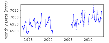
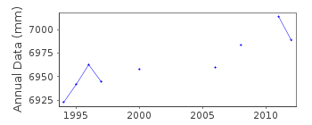
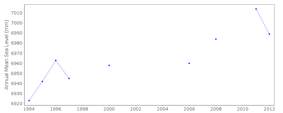
| Time span of data: | 1993 – 2013 |
| Completeness (%): | 63 |
| Link to ellipsoid: | Available |
| Date of last update: | 02 Oct 2014 |
| Green Arrow: | Current Station |
| Yellow Marker: | Neighbouring RLR Station |
| Red Marker: | Neighbouring Metric Station |
Please note: In many cases, the station position in our database is accurate to only one minute. Thus, the tide gauge may not appear to be on the coast.
Tide Gauge Data
Additional Data Sources (guide to additional data sources)
Nearby GNSS Stations from SONEL: ASC1, ASCGNearby Real Time Stations from VLIZ: ascen
Fast Delivery Data from UHSLC station 291: hourly and daily
Research Quality Data from UHSLC station 291: hourly and daily
Station Documentation
Link to RLR information.Documentation added 1998-12-01
values for March 1997 to January 1998 were revised in November 1998Documentation added 1999-11-18
Original POL 'B gauge' installed May 1993 which ran until June1998, then replaced with new 'B gauge' in March 1999.
Documentation added 2000-04-26
Ascension 402/001 RLR(1993) is 10.184m below BM POL13Documentation added 2002-09-10
Ascension gauge failed March 2001.Documentation added 2014-06-30
The datum history at Ascension is complicated. Half-tide ref. 1993-1998 and 2006-2007 was used for the data June 1993-June 1998 and again for data Jan. 2006-Dec 2007. Half-tide datum Apr. 1999-Mar. 2001 was used specifically for that period. Half-tide ref. Ascension B datum Sept. 2005 was used for Nov. and Dec data 2005 and also data for Jan.2008- May 2010. Full tide datum B gauge 870mm below the original datum for 1993-1998 and 2006-2007 was used for data Dec. 2010 onwards.Data Authority
British Oceanographic Data CentreNational Oceanography Centre
Joseph Proudman Building, 6 Brownlow Street
Liverpool
L3 5DA

![]()
![]()
![]()
