Data
- Obtaining
- Supplying
- High-Frequency
- Bottom Pressure Records
- Other Long Records
- GLOSS/ODINAFRICA Calibration Data
Donate
Donate to PSMSL
Data Notes
- Individual Station Data and Plot Notes
- Referencing the Data Set
- PSMSL Help File
- 2010 Changes to the PSMSL Data Files
Extracted from Database
20 Jul 2026
WARNING: QCFLAG EXISTS. PLEASE READ THE DOCUMENTATION.
Station Information
| Station ID: | 1819 |
| Latitude: | 4.401111 |
| Longitude: | 113.974444 |
| Coastline code: | 663 |
| Station code: | 1 |
| Country: | MALAYSIA |
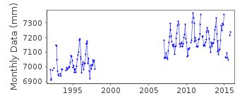
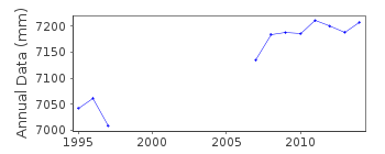
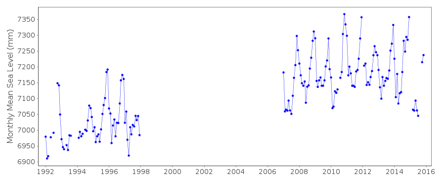
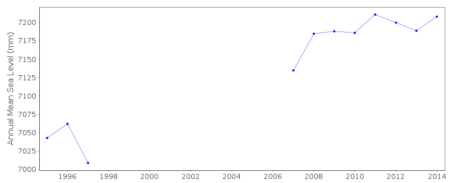
| Time span of data: | 1992 – 2015 |
| Completeness (%): | 56 |
| Date of last update: | 04 May 2017 |
| Green Arrow: | Current Station |
| Yellow Marker: | Neighbouring RLR Station |
| Red Marker: | Neighbouring Metric Station |
Please note: In many cases, the station position in our database is accurate to only one minute. Thus, the tide gauge may not appear to be on the coast.
Tide Gauge Data
Additional Data Sources (guide to additional data sources)
Research Quality Data from UHSLC station 388: hourly and dailyStation Documentation
Link to RLR information.Documentation added 1997-01-21
1995 data revised January 1997Documentation added 2010-08-12
Despite reassurance from the authority that the re-instated gauge at Miri has been levelled into the same Zero of Tide Gauge when plotted the data appears to be approximately 20cms higher than previously - because of this the station has been flagged as suspect.Documentation added 2014-10-09
The supplying authority JUPEM has supplied revised data values for Miri for 2013. These have been entered into the database.Documentation added 2019-08-27
The tide gauge at Miri has currently been decommissioned due to development at the location.Data Authority
Department of Survey and MappingWisma JUPEM
Jalan Semarak
50578 Kuala Lumpur

![]()
![]()
![]()
