Data
- Obtaining
- Supplying
- High-Frequency
- Bottom Pressure Records
- Other Long Records
- GLOSS/ODINAFRICA Calibration Data
Donate
Donate to PSMSL
Data Notes
- Individual Station Data and Plot Notes
- Referencing the Data Set
- PSMSL Help File
- 2010 Changes to the PSMSL Data Files
Extracted from Database
13 Jul 2026
Station Information
| Station ID: | 1817 |
| Latitude: | 45.54811 |
| Longitude: | 13.72455 |
| Coastline code: | 279 |
| Station code: | 3 |
| Country: | SLOVENIA |
| Time span of data: | 1992 – 2020 |
| Completeness (%): | 97 |
| Link to ellipsoid: | Available |
| Date of last update: | 17 Feb 2023 |
| Green Arrow: | Current Station |
| Yellow Marker: | Neighbouring RLR Station |
| Red Marker: | Neighbouring Metric Station |
Please note: In many cases, the station position in our database is accurate to only one minute. Thus, the tide gauge may not appear to be on the coast.
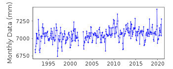
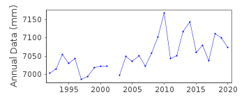
Tide Gauge Data
Station Documentation
Link to RLR information.Documentation added 1998-04-28
for 1992 onwards the gauge type=Seba-Delta float operatedDocumentation added 1999-05-11
1996 data revisedvalues for 1997-98 are preliminary
Luka Koper is an historic station last data 2003
Data Authority
Hydrometeorological Institute of SloveniaVojkova 1b
1001 Ljubljana, P.P. 2549

![]()
![]()
![]()
