Data
- Obtaining
- Supplying
- High-Frequency
- Bottom Pressure Records
- Other Long Records
- GLOSS/ODINAFRICA Calibration Data
Donate
Donate to PSMSL
Data Notes
- Individual Station Data and Plot Notes
- Referencing the Data Set
- PSMSL Help File
- 2010 Changes to the PSMSL Data Files
Extracted from Database
20 Jul 2026
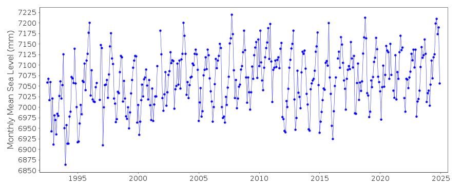
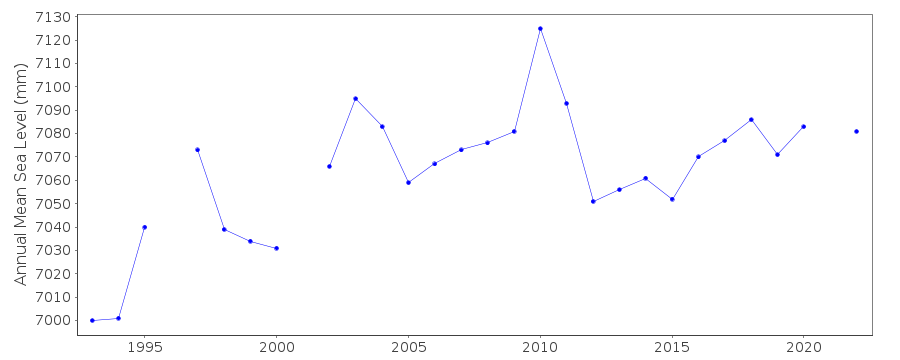
Station Information
| Station ID: | 1810 |
| Latitude: | 36.71184 |
| Longitude: | -4.41709 |
| Coastline code: | 220 |
| Station code: | 32 |
| Country: | SPAIN |
| Time span of data: | 1992 – 2025 |
| Completeness (%): | 97 |
| Link to ellipsoid: | Available |
| Date of last update: | 17 Jul 2026 |
| Green Arrow: | Current Station |
| Yellow Marker: | Neighbouring RLR Station |
| Red Marker: | Neighbouring Metric Station |
Please note: In many cases, the station position in our database is accurate to only one minute. Thus, the tide gauge may not appear to be on the coast.
Tide Gauge Data
Additional Data Sources (guide to additional data sources)
Nearby GNSS Stations from SONEL: MALANearby Real Time Stations from VLIZ: mal3
Station Documentation
Link to RLR information.Documentation added 2000-10-19
Malaga II, new station 1992. Data supplied by Climat Maritimo, Madrid.RLR(1993) is 7.694m below BM SSK 236.
Documentation added 2013-03-18
The SRD acoustic gauge at Malaga has been moved and replaced by a new MIROS radar sensor.Both new and old gauges were running for the period 22.01.2009-23.04.2010 for
inter-comparison purposes. A bias (mean difference) of 0.18cm was calculated. See paper
by B. Perez et al 'Overlapping sea level time series measured using different
technologies: an example from the REDMAR Spanish network'.
Documentation added 2014-01-13
Further investigation revealed that the bias was due to a problem in the old Acoustic gauge. Data from this was revised. Complete dataset was re-entered onto the database.Documentation added 2014-04-29
At the request of Puertos del Estado the latitude and longitude have been revised from 36.716667 -4.416667 derived from the previously supplied degrees and minutes value to 36.71184 -4.41709 the site of the new MIROS gauge in decimal degrees.Data Authority
Puertos del EstadoÁrea de Conocimiento y Análisis del Medio Físico
Avda. Del Partenón, 10
28042, Madrid
Documentation added 2001-03-06
The Area de Conocimiento y Analisis del Medio Fisico wasformerly known as the Departamento de Clima Maritimo.

![]()
![]()
![]()
