Data
- Obtaining
- Supplying
- High-Frequency
- Bottom Pressure Records
- Other Long Records
- GLOSS/ODINAFRICA Calibration Data
Donate
Donate to PSMSL
Data Notes
- Individual Station Data and Plot Notes
- Referencing the Data Set
- PSMSL Help File
- 2010 Changes to the PSMSL Data Files
Extracted from Database
20 Jul 2026
Station Information
| Station ID: | 1802 |
| Latitude: | 28.14056 |
| Longitude: | -15.41181 |
| GLOSS ID: | 251 |
| Coastline code: | 370 |
| Station code: | 46 |
| Country: | SPAIN |
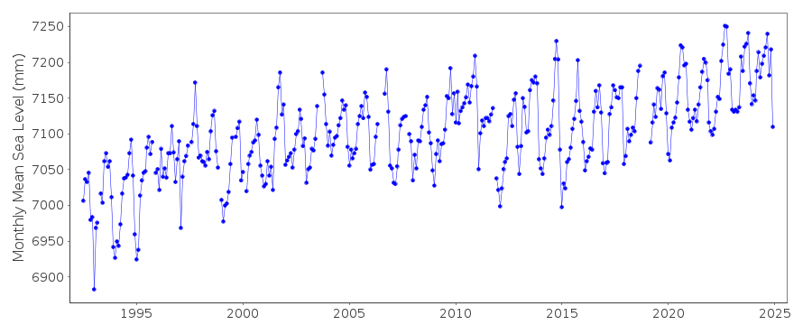
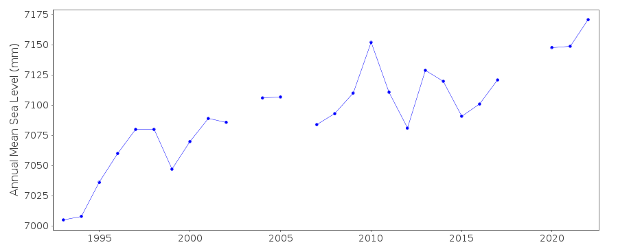
| Time span of data: | 1992 – 2025 |
| Completeness (%): | 94 |
| Link to ellipsoid: | Available |
| Date of last update: | 17 Jul 2026 |
| Green Arrow: | Current Station |
| Yellow Marker: | Neighbouring RLR Station |
| Red Marker: | Neighbouring Metric Station |
Please note: In many cases, the station position in our database is accurate to only one minute. Thus, the tide gauge may not appear to be on the coast.
Tide Gauge Data
Additional Data Sources (guide to additional data sources)
Nearby GNSS Stations from SONEL: PLUZ, ULP2Nearby Real Time Stations from VLIZ: lasp
Fast Delivery Data from UHSLC station 217: hourly and daily
Research Quality Data from UHSLC station 217: hourly and daily
Station Documentation
Link to RLR information.Documentation added 2000-10-19
RLR(1994) is 9.791m below NGU 340.Documentation added 2006-11-28
2003 data onwards flagged - data looks suspect.Documentation added 2009-02-11
Confirmed by Begona there has been a datum shift in Las Palmas. Awaiting precise information so that RLR can be adjusted.Documentation added 2011-01-20
When adding data for 2008/9 it was noticed that the early 1990's data values on the database differed from those now supplied by the PE . These erroneous values were traced back to the data first being supplied in 2004. Whole dataset was re-entered. This is one of the stations that is to be completely replaced eventually as a new radar gauge has now been installed.Station made RLR. RLR year 1994 factor 5.505m.
Documentation added 2013-03-18
The SRD acoustic gauge at Las Palmas has been moved and replaced with a MIROS radar sensor. Both old and new gauges were running for the period 01.01.2009-29.04.2010 for inter-comparison purposes. A bias (mean difference) of -0.10cm was calculated between the two gauges. Hardware problems (de-lamination) occurred with the new Miros gauge and the datum differs by -4cm from Nov. 2011. This has been accounted for in the supplied data. See paper by B. Perez et al 'Overlapping sea level time series measured using different technologies: an example from the REDMAR Spanish network'.Documentation added 2014-01-13
Further investigation revealed that the bias was due to a problem with the old Acoustic gauge. Data from this has been revised. Complete dataset was re-entered onto the database.Documentation added 2014-04-29
At the request of Puerto del Estado the latitude and longitude have been revised from 28.150000 -15.400000 derived from the previously supplied degrees and minutes value to 28.14056 -15.41181 which is the site of the new MIROS gauge in decimal degrees.Data Authority
Puertos del EstadoÁrea de Conocimiento y Análisis del Medio Físico
Avda. Del Partenón, 10
28042, Madrid
Documentation added 2001-03-06
The Area de Conocimiento y Analisis del Medio Fisico wasformerly known as the Departamento de Clima Maritimo.

![]()
![]()
![]()
