Data
- Obtaining
- Supplying
- High-Frequency
- Bottom Pressure Records
- Other Long Records
- GLOSS/ODINAFRICA Calibration Data
Donate
Donate to PSMSL
Data Notes
- Individual Station Data and Plot Notes
- Referencing the Data Set
- PSMSL Help File
- 2010 Changes to the PSMSL Data Files
Extracted from Database
13 Jul 2026
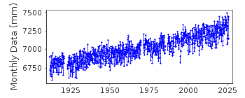
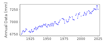
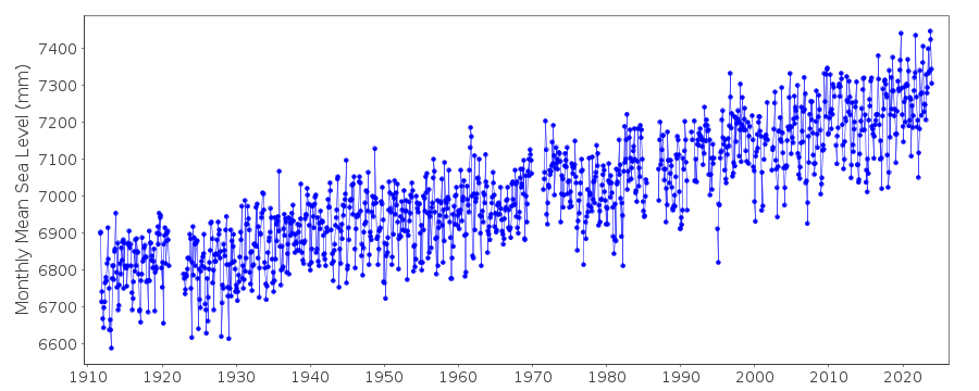
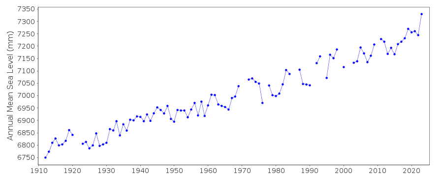
Station Information
| Station ID: | 180 |
| Latitude: | 39.355 |
| Longitude: | -74.418333 |
| GLOSS ID: | 220 |
| Coastline code: | 960 |
| Station code: | 91 |
| Country: | UNITED STATES |
| Time span of data: | 1911 – 2025 |
| Completeness (%): | 93 |
| Date of last update: | 27 Jan 2026 |
| Green Arrow: | Current Station |
| Yellow Marker: | Neighbouring RLR Station |
| Red Marker: | Neighbouring Metric Station |
Please note: In many cases, the station position in our database is accurate to only one minute. Thus, the tide gauge may not appear to be on the coast.
Tide Gauge Data
Additional Data Sources (guide to additional data sources)
Nearby GNSS Stations from SONEL: NJGTNearby Real Time Stations from VLIZ: acnj2, acnj
Fast Delivery Data from UHSLC station 264: hourly and daily
Research Quality Data from UHSLC station 264: hourly and daily
Station Documentation
Link to RLR information.Documentation - date unknown
Replaced by Ventnor City in 1985Documentation added 1991-06-11
Atlantic City 960/091 RLR(1964) is 11.0m below BM32Documentation added 1994-10-06
Reinstalled 1991 instead of Ventnor CityDocumentation added 1995-05-24
Ventnor City data combined with Atlantic City dataDocumentation added 1998-09-28
Severe storms in early 1995Documentation added 2011-08-11
The RLR diagram for Atlantic City has been re-drawn showing the now Primary benchmark 4720 F 1991.10.553m above the Station Datum. This information has been extracted from the NOAA website. The benchmark previously referred to BM 32 6.081m above Station Datum no longer appears on the NOAA website.Data Authority
N.O.A.A. / N.O.S.N/oes33, Ssmc4, Room 6531
1305 East-West Highway
Silver Spring,
MD 20910

![]()
![]()
![]()
