Data
- Obtaining
- Supplying
- High-Frequency
- Bottom Pressure Records
- Other Long Records
- GLOSS/ODINAFRICA Calibration Data
Donate
Donate to PSMSL
Data Notes
- Individual Station Data and Plot Notes
- Referencing the Data Set
- PSMSL Help File
- 2010 Changes to the PSMSL Data Files
Extracted from Database
13 Jul 2026
Station Information
| Station ID: | 1797 |
| Latitude: | 32.47044 |
| Longitude: | 34.86316 |
| GLOSS ID: | 80 |
| Coastline code: | 320 |
| Station code: | 16 |
| Country: | ISRAEL |
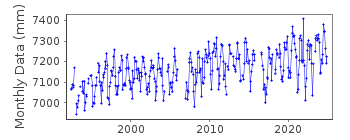
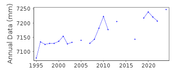
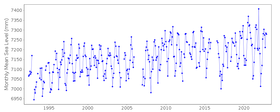
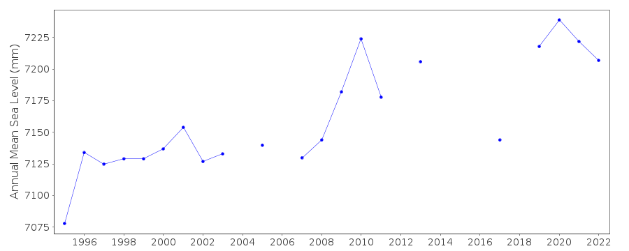
| Time span of data: | 1992 – 2025 |
| Completeness (%): | 88 |
| Link to ellipsoid: | Available |
| Date of last update: | 06 Jul 2026 |
| Green Arrow: | Current Station |
| Yellow Marker: | Neighbouring RLR Station |
| Red Marker: | Neighbouring Metric Station |
Please note: In many cases, the station position in our database is accurate to only one minute. Thus, the tide gauge may not appear to be on the coast.
Tide Gauge Data
Station Documentation
Link to RLR information.Documentation added 1999-09-02
1997 revised on receipt of complete year of dataDocumentation added 2000-04-26
Hadera 320/016 RLR(1999) is 11m below TGBM 0013Data Authority
Israel Oceanographic and Limnological Research Ltd.Tel Shikmona
P.O. Box 8030
Haifa 31080

![]()
![]()
![]()
