Data
- Obtaining
- Supplying
- High-Frequency
- Bottom Pressure Records
- Other Long Records
- GLOSS/ODINAFRICA Calibration Data
Donate
Donate to PSMSL
Data Notes
- Individual Station Data and Plot Notes
- Referencing the Data Set
- PSMSL Help File
- 2010 Changes to the PSMSL Data Files
Extracted from Database
20 Jul 2026
Station Information
| Station ID: | 1793 |
| Latitude: | 54.085389 |
| Longitude: | -4.768056 |
| Coastline code: | 170 |
| Station code: | 233 |
| Country: | ISLE OF MAN |
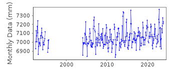
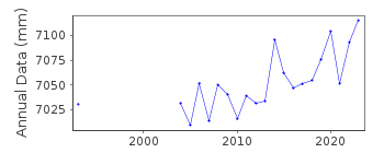
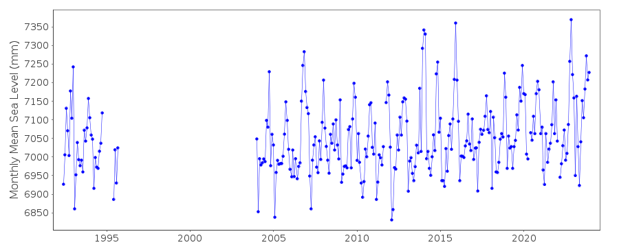
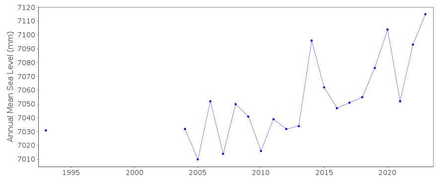
| Time span of RLR data: | 1992 – 2025 |
| RLR completeness (%): | 72 |
| Time span of metric data: | 1992 – 2025 |
| Metric completeness (%): | 89 |
| Date of last update: | 19 Feb 2026 |
| Green Arrow: | Current Station |
| Yellow Marker: | Neighbouring RLR Station |
| Red Marker: | Neighbouring Metric Station |
Please note: In many cases, the station position in our database is accurate to only one minute. Thus, the tide gauge may not appear to be on the coast.
Tide Gauge Data
Station Documentation
Link to RLR information.Documentation added 1994-07-20
Gauge is an "A Class" bubbler maintained by POL.Documentation added 2001-01-02
Recent work on vertical land movements in the UK can be found fromthe University of Nottingham web site:
http://ukcogr.iessg.nottingham.ac.uk/~eosi/
Documentation added 2014-07-03
TGI visited the site on both 30.01.2013 and 08.10.2013 to carry out general maintenance and change the compressor.Documentation added 2015-06-02
Readings were ~30mm high during January. There were no site visits during 2014.Documentation added 2015-07-30
It has come to light that there is possibly a datum issue at Port Erin for the period 1998-2003. While this is being investigated this portion of the data has been switched to Metric.Data Authority
Environment AgencyHorizon House
Deanery Road
BS1 5AH
Bristol

![]()
![]()
![]()
