Data
- Obtaining
- Supplying
- High-Frequency
- Bottom Pressure Records
- Other Long Records
- GLOSS/ODINAFRICA Calibration Data
Donate
Donate to PSMSL
Data Notes
- Individual Station Data and Plot Notes
- Referencing the Data Set
- PSMSL Help File
- 2010 Changes to the PSMSL Data Files
Extracted from Database
13 Jul 2026
Station Information
| Station ID: | 1792 |
| Latitude: | 10.45 |
| Longitude: | 99.25 |
| Coastline code: | 600 |
| Station code: | 11 |
| Country: | THAILAND |
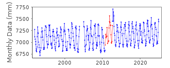
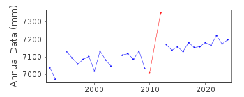
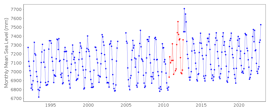
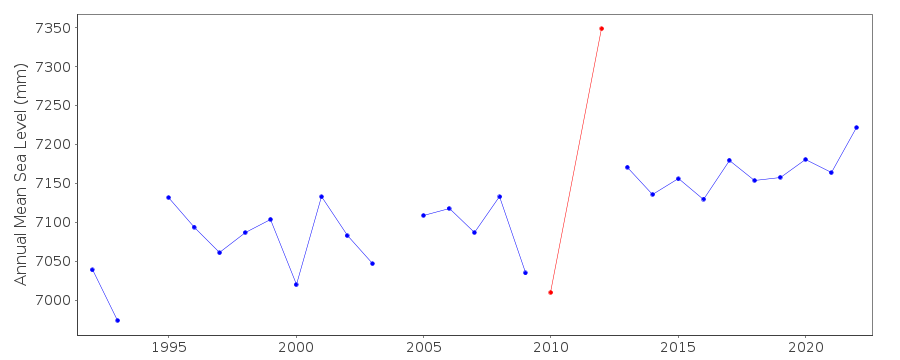
| Time span of data: | 1992 – 2024 |
| Completeness (%): | 95 |
| Date of last update: | 04 Aug 2025 |
| Green Arrow: | Current Station |
| Yellow Marker: | Neighbouring RLR Station |
| Red Marker: | Neighbouring Metric Station |
Please note: In many cases, the station position in our database is accurate to only one minute. Thus, the tide gauge may not appear to be on the coast.
Tide Gauge Data
Station Documentation
Link to RLR information.Documentation added 2002-05-13
Ko Mattaphon 600/011 RLR(1993) is 10.3m below BM 127Documentation added 2011-07-11
While checking details before releasing the RLR diagram online it was noted that from 1998 data onwards the benchmark becomes BM 126 5.6848m above the datum of the tide gauge. The RLR diagram was adjusted accordingly.Documentation added 2014-09-08
The supplying authority has confirmed that following re-organisation in October 2010 the data quality at station Ko Mattaphon deteriorated data during this period - October 2010-August 2012 has been flagged. The old float gauge was replaced by a radar gauge in September 2012. Data following the gauge replacement is again good quality data.Data Authority
Oceanographic DivisionHydrographic Department
Royal Thai Navy
222 Rimtang-Rodfai-kao Road
Bangna, Bangkok 10260

![]()
![]()
![]()
