Data
- Obtaining
- Supplying
- High-Frequency
- Bottom Pressure Records
- Other Long Records
- GLOSS/ODINAFRICA Calibration Data
Donate
Donate to PSMSL
Data Notes
- Individual Station Data and Plot Notes
- Referencing the Data Set
- PSMSL Help File
- 2010 Changes to the PSMSL Data Files
Extracted from Database
13 Jul 2026
Station Information
| Station ID: | 1775 |
| Latitude: | 58.456611 |
| Longitude: | -5.050361 |
| Coastline code: | 170 |
| Station code: | 255 |
| Country: | UNITED KINGDOM |
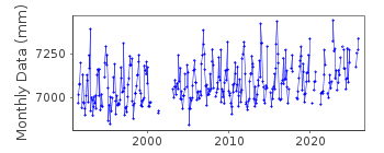
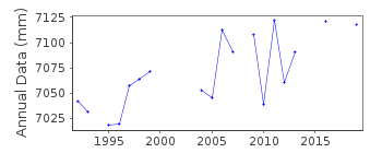
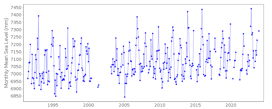
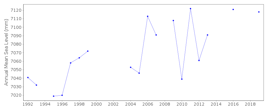
| Time span of data: | 1991 – 2025 |
| Completeness (%): | 80 |
| Date of last update: | 19 Feb 2026 |
| Green Arrow: | Current Station |
| Yellow Marker: | Neighbouring RLR Station |
| Red Marker: | Neighbouring Metric Station |
Please note: In many cases, the station position in our database is accurate to only one minute. Thus, the tide gauge may not appear to be on the coast.
Tide Gauge Data
Additional Data Sources (guide to additional data sources)
Nearby GNSS Stations from SONEL: KINLNearby Real Time Stations from VLIZ: kinl
Station Documentation
Link to RLR information.Documentation added 1994-07-20
Gauge is an "A Class" bubbler maintained by POL.Documentation added 2000-04-25
Kinlochbervie 170/255 RLR(1993) is 11.4m below TGBM NC 2206 5613Documentation added 2001-01-02
Recent work on vertical land movements in the UK can be found fromthe University of Nottingham web site:
http://ukcogr.iessg.nottingham.ac.uk/~eosi/
Documentation added 2014-07-03
TGI visted the site on 26.03.2013 for general maintenance and again on the 16.07.2013 for general maintenance and change the compressor.Documentation added 2015-06-02
TGI were at site 08.10.1 for general maintenance and to change the compressor. Channel was blocking during November and December with a loss of data.Data Authority
Environment AgencyHorizon House
Deanery Road
BS1 5AH
Bristol

![]()
![]()
![]()
