Data
- Obtaining
- Supplying
- High-Frequency
- Bottom Pressure Records
- Other Long Records
- GLOSS/ODINAFRICA Calibration Data
Donate
Donate to PSMSL
Data Notes
- Individual Station Data and Plot Notes
- Referencing the Data Set
- PSMSL Help File
- 2010 Changes to the PSMSL Data Files
Extracted from Database
20 Jul 2026
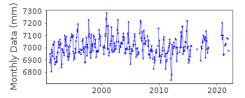
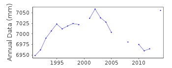
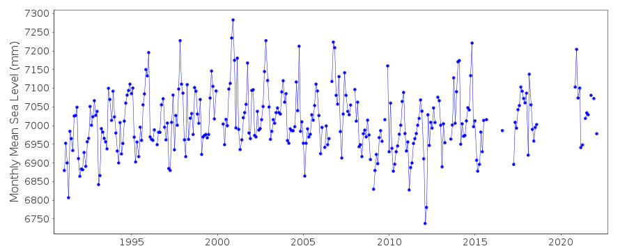
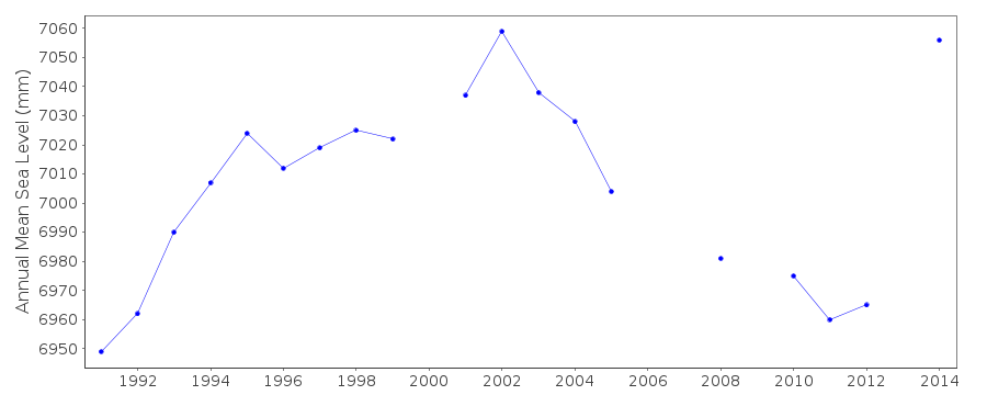
Station Information
| Station ID: | 1773 |
| Latitude: | 50.6085 |
| Longitude: | -2.447944 |
| Coastline code: | 170 |
| Station code: | 150 |
| Country: | UNITED KINGDOM |
| Time span of data: | 1991 – 2022 |
| Completeness (%): | 80 |
| Date of last update: | 19 Feb 2026 |
| Green Arrow: | Current Station |
| Yellow Marker: | Neighbouring RLR Station |
| Red Marker: | Neighbouring Metric Station |
Please note: In many cases, the station position in our database is accurate to only one minute. Thus, the tide gauge may not appear to be on the coast.
Tide Gauge Data
Additional Data Sources (guide to additional data sources)
Nearby GNSS Stations from SONEL: PBILNearby Real Time Stations from VLIZ: weym
Station Documentation
Link to RLR information.Documentation added 1993-09-22
Weymouth 170/150 RLR(1992) is 10.2m below TGBM SY 6826 7882Documentation added 1994-09-20
An "A class" bubbler gauge operated by POL since 30 January 1991Documentation added 2001-01-02
Recent work on vertical land movements in the UK can be found fromthe University of Nottingham web site:
http://ukcogr.iessg.nottingham.ac.uk/~eosi/
Documentation added 2014-07-04
During May 2013 the primary channel started blocking and because of this was recording over 20mm high. On 11.08.2013 TGI were at site to purge the system and carry out general maintenance. While there they also changed the compressor and further investigated the blocking channel.Documentation added 2015-06-02
At the beginning of 2014 there were again problems with channel blocking. TGI were at site 15.01.14 to clear the pneumatic line blockage and again on 03.04.14 for general maintenence and to dive to inspect and again clear the blocking channel.Data Authority
Environment AgencyHorizon House
Deanery Road
BS1 5AH
Bristol

![]()
![]()
![]()
