Data
- Obtaining
- Supplying
- High-Frequency
- Bottom Pressure Records
- Other Long Records
- GLOSS/ODINAFRICA Calibration Data
Donate
Donate to PSMSL
Data Notes
- Individual Station Data and Plot Notes
- Referencing the Data Set
- PSMSL Help File
- 2010 Changes to the PSMSL Data Files
Extracted from Database
20 Jul 2026
Station Information
| Station ID: | 1771 |
| Latitude: | 52.719333 |
| Longitude: | -4.045028 |
| Coastline code: | 170 |
| Station code: | 187 |
| Country: | UNITED KINGDOM |
| Time span of data: | 1991 – 2025 |
| Completeness (%): | 53 |
| Date of last update: | 19 Feb 2026 |
| Green Arrow: | Current Station |
| Yellow Marker: | Neighbouring RLR Station |
| Red Marker: | Neighbouring Metric Station |
Please note: In many cases, the station position in our database is accurate to only one minute. Thus, the tide gauge may not appear to be on the coast.
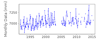
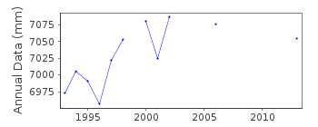
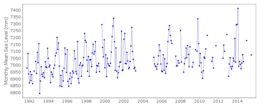
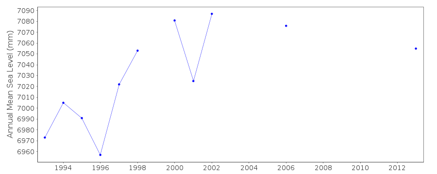
Tide Gauge Data
Additional Data Sources (guide to additional data sources)
Nearby Real Time Stations from VLIZ: barmStation Documentation
Link to RLR information.Documentation added 1994-07-20
Gauge is an "A Class" bubbler maintained by POL.Documentation added 2000-04-25
Barmouth 170/187 RLR(1994) is 14.7m below BM SH 6197 1548Documentation added 2001-01-02
Recent work on vertical land movements in the UK can be found fromthe University of Nottingham web site:
http://ukcogr.iessg.nottingham.ac.uk/~eosi/
Documentation added 2014-07-02
14.01.2013 both full tide pressure points damaged by debris.A temporary repair was made in Feb. 2013. Council accidently switched the power off at the beginning of April. TGI were at site 09.04.2013 to install new compressor and re-instate the power.Documentation added 2015-05-06
TGI were at site 12.11.2014 for general maintenance and to change the compresssor. All data is subject to lagging on the falling tide particularly over springs. No levelling was carried out during 2014.Data Authority
Environment AgencyHorizon House
Deanery Road
BS1 5AH
Bristol

![]()
![]()
![]()
