Data
- Obtaining
- Supplying
- High-Frequency
- Bottom Pressure Records
- Other Long Records
- GLOSS/ODINAFRICA Calibration Data
Donate
Donate to PSMSL
Data Notes
- Individual Station Data and Plot Notes
- Referencing the Data Set
- PSMSL Help File
- 2010 Changes to the PSMSL Data Files
Extracted from Database
13 Jul 2026
Station Information
| Station ID: | 1758 |
| Latitude: | 51.210611 |
| Longitude: | -3.131333 |
| Coastline code: | 170 |
| Station code: | 168 |
| Country: | UNITED KINGDOM |
| Time span of data: | 1990 – 2025 |
| Completeness (%): | 77 |
| Date of last update: | 19 Feb 2026 |
| Green Arrow: | Current Station |
| Yellow Marker: | Neighbouring RLR Station |
| Red Marker: | Neighbouring Metric Station |
Please note: In many cases, the station position in our database is accurate to only one minute. Thus, the tide gauge may not appear to be on the coast.
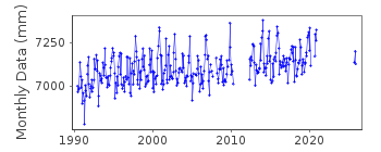
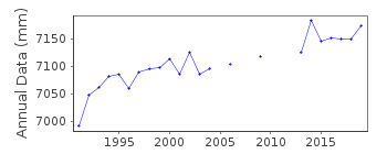
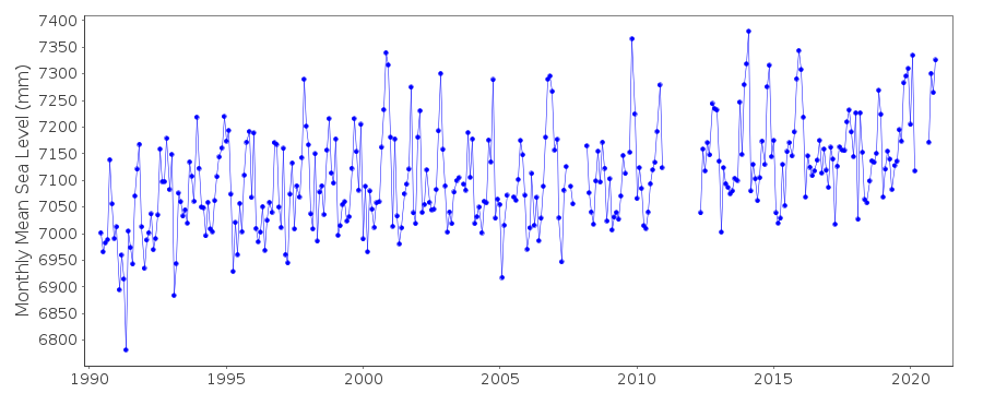
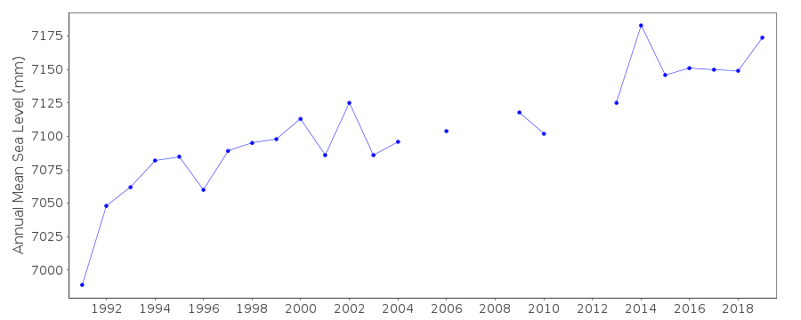
Tide Gauge Data
Additional Data Sources (guide to additional data sources)
Nearby Real Time Stations from VLIZ: hinkStation Documentation
Link to RLR information.Documentation added 1994-07-20
An "A Class" bubbler system installed in March 1990.Documentation added 1994-09-21
Hinkley Point 170/168 RLR(1992) is 15.6m below TGBM ST 2104 4634Documentation added 2001-01-02
Recent work on vertical land movements in the UK can be found fromthe University of Nottingham web site:
http://ukcogr.iessg.nottingham.ac.uk/~eosi/
Documentation added 2006-11-15
Historic tige gauge information: Initially gauge fitted withincorrect datum level.
September 1991 underwater transducers lifted and re-levelled.
Documentation added 2006-11-15
Historic tige gauge information: Initially gauge fitted withincorrect datum level.
September 1991 underwater transducers lifted and re-levelled.
Documentation added 2014-07-03
Due to fouling of the sensors additional sensors were installed in May 2012. For the 2013 data some of the low waters were flagged due to siltation.Documentation added 2015-06-02
TGI were at site 12.03.14 and again 12.06.14 for general maintenance. Data from Channel2 has been flagged throughout due to fouling of the sensor. Channel1 was flagged over some low waters possibly due to the effects of turbulance during stormy weather.Data Authority
Environment AgencyHorizon House
Deanery Road
BS1 5AH
Bristol

![]()
![]()
![]()
