Data
- Obtaining
- Supplying
- High-Frequency
- Bottom Pressure Records
- Other Long Records
- GLOSS/ODINAFRICA Calibration Data
Donate
Donate to PSMSL
Data Notes
- Individual Station Data and Plot Notes
- Referencing the Data Set
- PSMSL Help File
- 2010 Changes to the PSMSL Data Files
Extracted from Database
20 Jul 2026
Station Information
| Station ID: | 1747 |
| Latitude: | 46.497501 |
| Longitude: | -1.79373 |
| Coastline code: | 190 |
| Station code: | 116 |
| Country: | FRANCE |
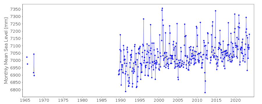
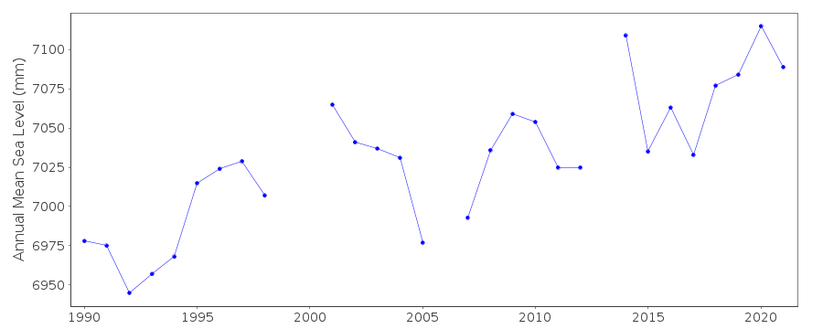
| Time span of data: | 1965 – 2025 |
| Completeness (%): | 58 |
| Date of last update: | 20 Feb 2026 |
| Green Arrow: | Current Station |
| Yellow Marker: | Neighbouring RLR Station |
| Red Marker: | Neighbouring Metric Station |
Please note: In many cases, the station position in our database is accurate to only one minute. Thus, the tide gauge may not appear to be on the coast.
Tide Gauge Data
Additional Data Sources (guide to additional data sources)
Nearby GNSS Stations from SONEL: SABLNearby Real Time Stations from VLIZ: leso2, leso
Station Documentation
Link to RLR information.Documentation added 2000-04-25
Les Sables d'Olonne 190/116 RLR(1996) is 13.3m below BM NGF OHI-LADocumentation added 2000-08-31
Sables d'Olonne acoustic gauge installed 11/05/1999.Documentation added 2012-03-29
Primary benchmark for Les Sables d'Olonne is now IGN O.HI - 65 7.756m above Zero Hydrographique.Documentation added 2014-10-01
Using data from SONEL the latitude and longitude for Les Sables D'Olonne has been revised.Documentation added 2016-06-29
When the data were downloaded from SONEL it was found that there were a number of revisions to the dataset. Because of this the complete dataset was re-loaded.Documentation added 2025-07-15
Updated the whole dataset to ensure they include all the historical data recovered recently by SHOM and the calculated monthly and annual means match those distributed by SONEL.Data Authority
SHOM13 rue de Chatelier
29200 BREST

![]()
![]()
![]()
