Data
- Obtaining
- Supplying
- High-Frequency
- Bottom Pressure Records
- Other Long Records
- GLOSS/ODINAFRICA Calibration Data
Donate
Donate to PSMSL
Data Notes
- Individual Station Data and Plot Notes
- Referencing the Data Set
- PSMSL Help File
- 2010 Changes to the PSMSL Data Files
Extracted from Database
13 Jul 2026
Station Information
| Station ID: | 1732 |
| Latitude: | 51.57 |
| Longitude: | -3.975444 |
| Coastline code: | 170 |
| Station code: | 179 |
| Country: | UNITED KINGDOM |
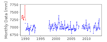
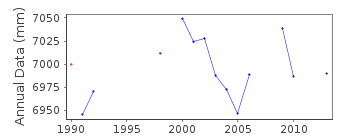
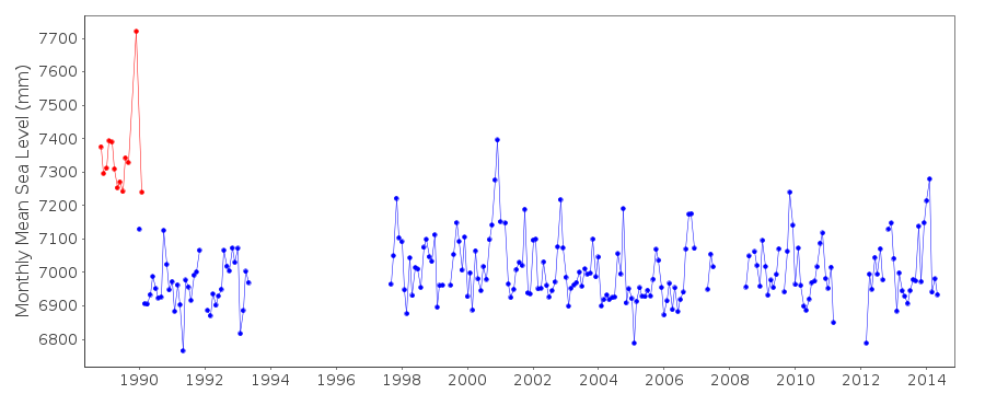
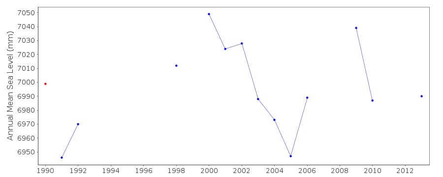
| Time span of data: | 1988 – 2014 |
| Completeness (%): | 68 |
| Date of last update: | 19 Feb 2026 |
| Green Arrow: | Current Station |
| Yellow Marker: | Neighbouring RLR Station |
| Red Marker: | Neighbouring Metric Station |
Please note: In many cases, the station position in our database is accurate to only one minute. Thus, the tide gauge may not appear to be on the coast.
Tide Gauge Data
Station Documentation
Link to RLR information.Documentation added 1994-07-20
An Aanderaa pressure system installed in 1988 was replaced in January1989 by an "A Class" bubbler.
Documentation added 1994-09-08
Aanderaa data used for MSL to end of July 1990Documentation added 2001-01-02
Recent work on vertical land movements in the UK can be found fromthe University of Nottingham web site:
http://ukcogr.iessg.nottingham.ac.uk/~eosi/
Documentation added 2012-05-17
Mumbles has been made RLR. Primary benchmark is TGBM 13.821m above TGZ (ACD).Documentation added 2014-07-03
TGI visited the site on 06.12.2013 to change the compressor.Documentation added 2015-06-02
From April 2014 there were problems with power loss due to contractors working on site. There is no data after 12.06.14. TGI were at site 18.06.14 for general maintenance and to investigate the power loss and on 07.11.14 again to carry out general maintenance. The tide gauge is to be re-instated on Mumbles pier during 2015.Data Authority
Environment AgencyHorizon House
Deanery Road
BS1 5AH
Bristol

![]()
![]()
![]()
