Data
- Obtaining
- Supplying
- High-Frequency
- Bottom Pressure Records
- Other Long Records
- GLOSS/ODINAFRICA Calibration Data
Donate
Donate to PSMSL
Data Notes
- Individual Station Data and Plot Notes
- Referencing the Data Set
- PSMSL Help File
- 2010 Changes to the PSMSL Data Files
Extracted from Database
13 Jul 2026
Station Information
| Station ID: | 1731 |
| Latitude: | 52.013222 |
| Longitude: | -4.98375 |
| Coastline code: | 170 |
| Station code: | 184 |
| Country: | UNITED KINGDOM |
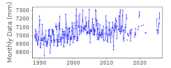
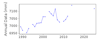
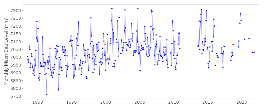
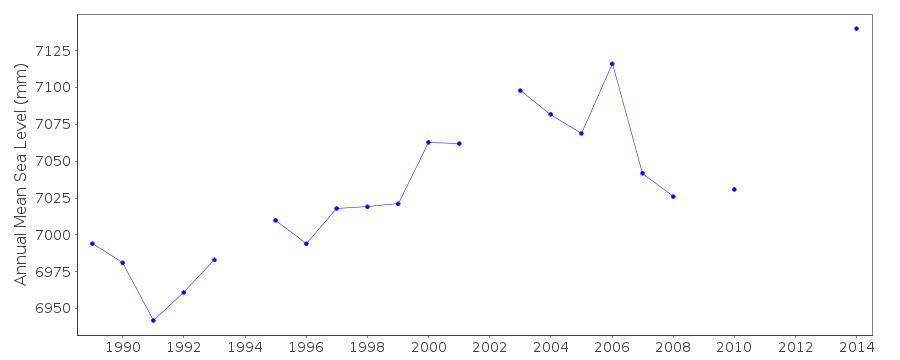
| Time span of data: | 1988 – 2025 |
| Completeness (%): | 76 |
| Date of last update: | 19 Feb 2026 |
| Green Arrow: | Current Station |
| Yellow Marker: | Neighbouring RLR Station |
| Red Marker: | Neighbouring Metric Station |
Please note: In many cases, the station position in our database is accurate to only one minute. Thus, the tide gauge may not appear to be on the coast.
Tide Gauge Data
Additional Data Sources (guide to additional data sources)
Nearby Real Time Stations from VLIZ: fishStation Documentation
Link to RLR information.Documentation added 1993-09-22
BENCH MARK INFORMATION 22 SEPTEMBER 1993FISHGUARD II RLR(1990) is 12.2m below BM SM 9534 3918
Documentation added 1994-07-20
An "A Class" bubbler gauge installed in June 1988.Documentation added 2001-01-02
Recent work on vertical land movements in the UK can be found fromthe University of Nottingham web site:
http://ukcogr.iessg.nottingham.ac.uk/~eosi/
Documentation added 2013-05-09
Site was levelled on 09.03.2013. On inspection both full tide sensors were found to be in mud both recording ~40mm high. As both full tide channels were buried in silt. MSL values re-computed back to September 2010. As a result 2011/12 data have been deleted.Documentation added 2014-07-03
On 18.07.2013 TGI were on site to carry out general maintenance and clear the silted pressure points.Documentation added 2015-05-06
Some readings during April 2014 were ~40mm high. TGI were at site 06.11.14 for general maintenance and to change the compressor. No levelling was carried out during 2014.Data Authority
Environment AgencyHorizon House
Deanery Road
BS1 5AH
Bristol

![]()
![]()
![]()
