Data
- Obtaining
- Supplying
- High-Frequency
- Bottom Pressure Records
- Other Long Records
- GLOSS/ODINAFRICA Calibration Data
Donate
Donate to PSMSL
Data Notes
- Individual Station Data and Plot Notes
- Referencing the Data Set
- PSMSL Help File
- 2010 Changes to the PSMSL Data Files
Extracted from Database
13 Jul 2026
Station Information
| Station ID: | 1710 |
| Latitude: | 28.965827 |
| Longitude: | -13.537869 |
| Coastline code: | 370 |
| Station code: | 4 |
| Country: | SPAIN |
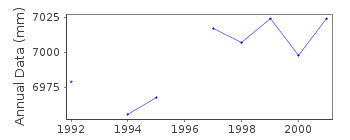
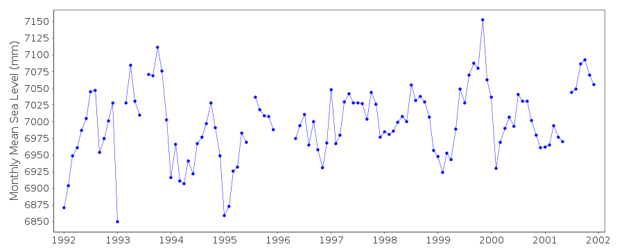
| Time span of RLR data: | 1992 – 2001 |
| RLR completeness (%): | 93 |
| Time span of metric data: | 1987 – 2001 |
| Metric completeness (%): | 90 |
| Date of last update: | 15 May 2002 |
| Green Arrow: | Current Station |
| Yellow Marker: | Neighbouring RLR Station |
| Red Marker: | Neighbouring Metric Station |
Please note: In many cases, the station position in our database is accurate to only one minute. Thus, the tide gauge may not appear to be on the coast.
Tide Gauge Data

Additional Data Sources (guide to additional data sources)
Nearby GNSS Stations from SONEL: TIAS, LZ02Nearby Real Time Stations from VLIZ: arre
Research Quality Data from UHSLC station 205: hourly and daily
Station Documentation
Link to RLR information.Documentation added 2000-04-25
Arrecife D 370/004 RLR(1998) is 9.5m below BM SSMFoDocumentation added 2002-03-27
Gauge replaced 1998 "in new place, very close to previous place".Data Authority
Instituto Español de OceanografíaCorazón de María, 8
28002, Madrid

![]()
![]()
![]()
