Data
- Obtaining
- Supplying
- High-Frequency
- Bottom Pressure Records
- Other Long Records
- GLOSS/ODINAFRICA Calibration Data
Donate
Donate to PSMSL
Data Notes
- Individual Station Data and Plot Notes
- Referencing the Data Set
- PSMSL Help File
- 2010 Changes to the PSMSL Data Files
Extracted from Database
20 Jul 2026
Station Information
| Station ID: | 1708 |
| Latitude: | 9.783333 |
| Longitude: | 125.5 |
| Coastline code: | 660 |
| Station code: | 151 |
| Country: | PHILIPPINES |
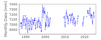
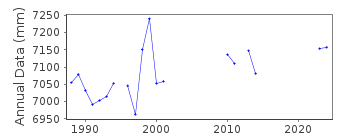
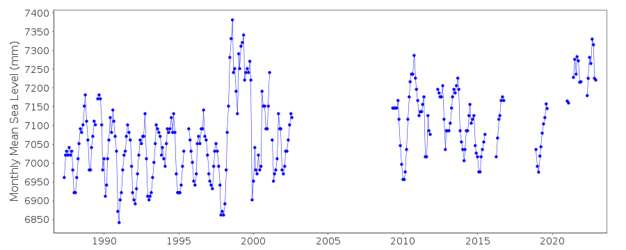
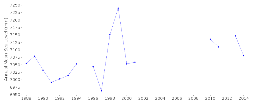
| Time span of data: | 1987 – 2025 |
| Completeness (%): | 68 |
| Date of last update: | 08 Jul 2026 |
| Green Arrow: | Current Station |
| Yellow Marker: | Neighbouring RLR Station |
| Red Marker: | Neighbouring Metric Station |
Please note: In many cases, the station position in our database is accurate to only one minute. Thus, the tide gauge may not appear to be on the coast.
Tide Gauge Data
Station Documentation
Link to RLR information.Documentation added 1991-06-11
Surigao 660/151 RLR(1988) is 8.9m below BM3Documentation added 1999-03-30
gauge type = Leupold & StevensDocumentation added 2010-10-20
Previous to 2009 data last data was August 2002. Datum remains TSO 1986 and Primary benchmark BM 3. However the relationship between the two has changed from previously 4.238m to 4.263m. The RLR factor has been modified to 4.637m to adjust for this.Documentation added 2012-02-27
Surigao was 'buddy checked' with Cebu both display an area of possible suspect data for the period Dec 1997-Dec 1999 because of this the data have not been flagged as suspect. Gauge type THALIMEDESDocumentation added 2018-12-06
No data was observed in Surigao due to port development. The station has been relocated temporarily at Port of Lipata in Surigao City. A new instrument has now been installed in Surigao City. Data observation will start as soon as possible.Data Authority
National Mapping and Resource Information AuthorityHydrography Department
421 Barraca St,
San Nicolas 1010
Manila

![]()
![]()
![]()
