Data
- Obtaining
- Supplying
- High-Frequency
- Bottom Pressure Records
- Other Long Records
- GLOSS/ODINAFRICA Calibration Data
Donate
Donate to PSMSL
Data Notes
- Individual Station Data and Plot Notes
- Referencing the Data Set
- PSMSL Help File
- 2010 Changes to the PSMSL Data Files
Extracted from Database
13 Jul 2026
Station Information
| Station ID: | 1707 |
| Latitude: | -0.683333 |
| Longitude: | 73.15 |
| GLOSS ID: | 27 |
| Coastline code: | 454 |
| Station code: | 2 |
| Country: | MALDIVES |
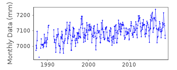
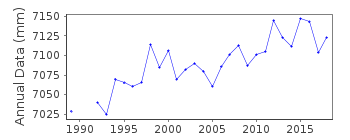
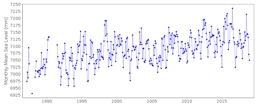
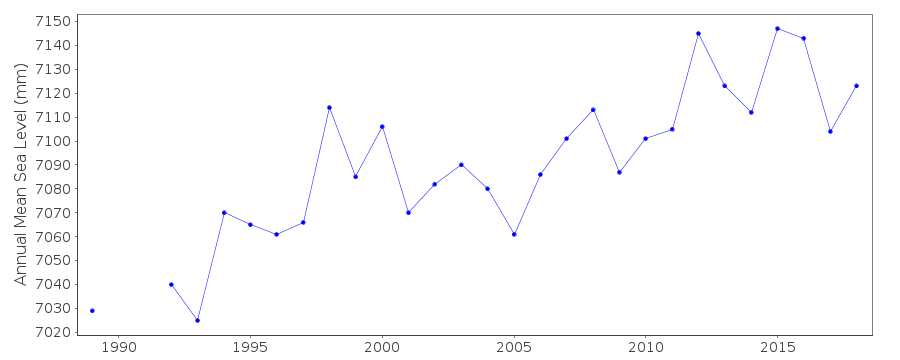
| Time span of data: | 1987 – 2018 |
| Completeness (%): | 94 |
| Date of last update: | 29 Jan 2020 |
| Green Arrow: | Current Station |
| Yellow Marker: | Neighbouring RLR Station |
| Red Marker: | Neighbouring Metric Station |
Please note: In many cases, the station position in our database is accurate to only one minute. Thus, the tide gauge may not appear to be on the coast.
Tide Gauge Data
Additional Data Sources (guide to additional data sources)
Nearby GNSS Stations from SONEL: ADDUNearby Real Time Stations from VLIZ: ganm
Fast Delivery Data from UHSLC station 109: hourly and daily
Research Quality Data from UHSLC station 109: hourly and daily
Station Documentation
Link to RLR information.Documentation added 1993-03-22
Data received from TOGA officeDocumentation added 1996-10-15
instrument type: analog (L&S); digital (F&P,ENC,ENB (03/1987-10/1988) Leupold and Stevens Analog gauge;(10/1988-06/1990) Fischer and Porter Analog-to- Digital Recorder;(1992-) Handar 436-A, Encoder (ENC);(1992-) Handar 436-B (ENB) float gaugesDocumentation added 2010-11-18
Complete dataset 1987-2009 received from UHSLC. These were checked against existing data values - they appear to be the same up until data following the gap Sept. 2002 after which the revised values are approx. 8mm lower. Complete dataset has been entered onto the database. RLR remains 5.490mDocumentation added 2013-10-15
Complete UHSLC dataset 1987-2012 added. Several revised data points throughout the data.Documentation added 2015-10-29
The complete updated JASL data through to 2014 has been loaded onto the database. Data supplier has also been updated from the Meteorological Station, Maldives to UHSLC.Documentation added 2015-12-08
After consulting the UH levelling sheets it became apparent that the original RLR diagram was prepared using the figures from the first levelling in 1987.The original benchmark '2' has since been destroyed. Primary benchmark since the 2002 levelling and stable through to the 2012 levelling is BM 4 3.656m above the Tide Staff Zero.Data Authority
University of Hawaii Sea Level CenterDepartment of Oceanography Division of Natural Sciences
1000 Pope Road
Honolulu
Hawaii 96822

![]()
![]()
![]()
