Data
- Obtaining
- Supplying
- High-Frequency
- Bottom Pressure Records
- Other Long Records
- GLOSS/ODINAFRICA Calibration Data
Donate
Donate to PSMSL
Data Notes
- Individual Station Data and Plot Notes
- Referencing the Data Set
- PSMSL Help File
- 2010 Changes to the PSMSL Data Files
Extracted from Database
13 Jul 2026
Station Information
| Station ID: | 1700 |
| Latitude: | 51.707389 |
| Longitude: | -5.051528 |
| Coastline code: | 170 |
| Station code: | 182 |
| Country: | UNITED KINGDOM |
| Time span of data: | 1987 – 2024 |
| Completeness (%): | 79 |
| Date of last update: | 19 Feb 2025 |
| Green Arrow: | Current Station |
| Yellow Marker: | Neighbouring RLR Station |
| Red Marker: | Neighbouring Metric Station |
Please note: In many cases, the station position in our database is accurate to only one minute. Thus, the tide gauge may not appear to be on the coast.
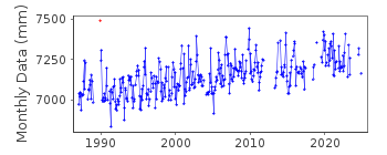
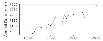
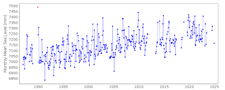
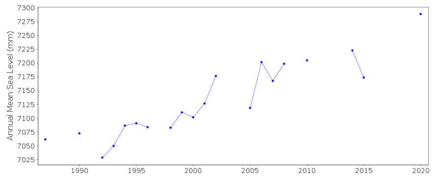
Tide Gauge Data
Additional Data Sources (guide to additional data sources)
Nearby GNSS Stations from SONEL: ANLXNearby Real Time Stations from VLIZ: mhav
Station Documentation
Link to RLR information.Documentation added 1993-09-22
Milford Haven (Hakin) 170/182 RLR(1992) is 20.0m below TGBM SM 8921 0536Documentation added 1994-07-20
An "A Class" bubbler was installed in December 1989. Prior to that various Munro systems had been used.Documentation added 2001-01-02
Recent work on vertical land movements in the UK can be found from the University of Nottingham web site: http://ukcogr.iessg.nottingham.ac.uk/~eosi/Documentation added 2006-11-29
Data for 1989 flagged due to spike Dec 1989.Documentation added 2006-11-29
Gap in dataset 2003 - 2004 due to gauge malfunction.Documentation added 2013-05-09
There are no MSL values for 2012. This is due to tube damage to the primary channel as a result it is recording approximately 40mm high.Documentation added 2014-07-03
During the beginning of 2013 the primary channel was occasionally recording 40-50mm out. On a site visit on 10.03.2013 the channels were cleaned and the gauge operation checked. Another visit was carried out on 18.07.2013 for general maintenance and to change the compressor.Documentation added 2015-06-02
During Jan-Mar values were erratic being +/-30mm. TGI were at site 07.11.14 to carry out general maintenance and to change the compressor.Data Authority
Environment AgencyHorizon House
Deanery Road
BS1 5AH
Bristol

![]()
![]()
![]()
