Data
- Obtaining
- Supplying
- High-Frequency
- Bottom Pressure Records
- Other Long Records
- GLOSS/ODINAFRICA Calibration Data
Donate
Donate to PSMSL
Data Notes
- Individual Station Data and Plot Notes
- Referencing the Data Set
- PSMSL Help File
- 2010 Changes to the PSMSL Data Files
Extracted from Database
20 Jul 2026
Station Information
| Station ID: | 17 |
| Latitude: | 60.6 |
| Longitude: | 21.233333 |
| Coastline code: | 60 |
| Station code: | 231 |
| Country: | FINLAND |
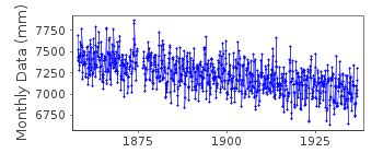
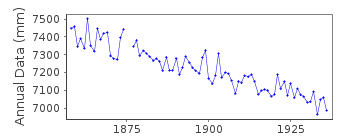
| Time span of data: | 1858 – 1936 |
| Completeness (%): | 98 |
| Date of last update: | 01 Jan 1980 |
| Green Arrow: | Current Station |
| Yellow Marker: | Neighbouring RLR Station |
| Red Marker: | Neighbouring Metric Station |
Please note: In many cases, the station position in our database is accurate to only one minute. Thus, the tide gauge may not appear to be on the coast.
Tide Gauge Data
Station Documentation
Link to RLR information.Documentation added 1991-06-11
Lypyrtti 060/231 RLR(1936) is 8.7m below BMDocumentation added 1993-07-12
Lypyrtti 060/231 RLR(1936) is 8.7m below BMDocumentation added 2002-09-24
A description of the sea level network in Finland can be foundin 'Operational Oceanography: Implementation at the European
and Regional scales. 2002 (pp.129-137)'.
1858 - 1913 VALUES BASED ON 1 READING PER DAY
NO BM INFORMATION BUT DATA SEEMS HOMOGENEOUS
Documentation added 2012-08-16
To allow the preparation of the RLR diagram for the PSMSL website thebenchmarks have been labelled a. and b.
Data Authority
Finnish Meteorological InstituteMarine Research, Waves and Sea Level
Erik Palenin aukio 1
P.O. Box 503
FI - 00101 Helsinki

![]()
![]()
![]()
