Data
- Obtaining
- Supplying
- High-Frequency
- Bottom Pressure Records
- Other Long Records
- GLOSS/ODINAFRICA Calibration Data
Donate
Donate to PSMSL
Data Notes
- Individual Station Data and Plot Notes
- Referencing the Data Set
- PSMSL Help File
- 2010 Changes to the PSMSL Data Files
Extracted from Database
20 Jul 2026
Station Information
| Station ID: | 1681 |
| Latitude: | 36.833333 |
| Longitude: | 30.616667 |
| Coastline code: | 310 |
| Station code: | 52 |
| Country: | TÜRKİYE |
| Time span of data: | 1985 – 2009 |
| Completeness (%): | 85 |
| Date of last update: | 09 Jul 2013 |
| Green Arrow: | Current Station |
| Yellow Marker: | Neighbouring RLR Station |
| Red Marker: | Neighbouring Metric Station |
Please note: In many cases, the station position in our database is accurate to only one minute. Thus, the tide gauge may not appear to be on the coast.
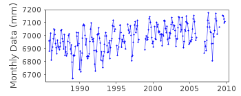
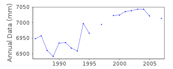
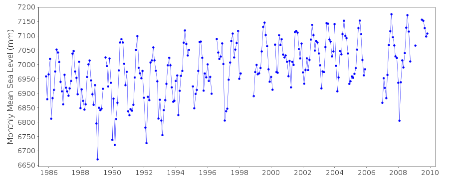
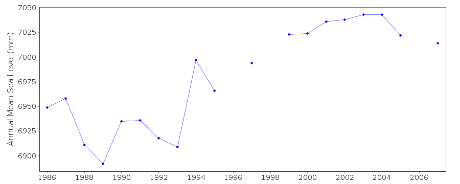
Tide Gauge Data
Additional Data Sources (guide to additional data sources)
Nearby Real Time Stations from VLIZ: antaStation Documentation
Link to RLR information.Documentation added 1999-09-03
Acoustic gauge (Aquatrak 4100 series sensor) installed in 1998Documentation added 2000-04-25
Antalya II 310/052 RLR(1992) is 7.4m below BM MAR 1Documentation added 2000-06-05
New analogue chart, float gauges were installed in 1985 in 4 Turkishstations: Antalya II, Bodrum II, Metes/Izmir and Erdek. All were
replaced by new acoustic systems in 1998-99.
Documentation added 2010-06-28
Antalya II is on the Eastern Mediterranean coast. The station forms part of theTurkish Sea Level Monitoring network.Coast/Station code 310/052 id=1681.Total
dataset has been updated
by the authority. A new RLR diagram was created. RLR (2007) is 8.000m below
TGBM ANTL-1. RLR factor is 4.836m.
Documentation added 2019-07-23
Scientists from a number of German Environmental and Geoscience Institutes have published a paper in the Journal of Geophysical Research (JGR-Oceans) describing the analysis of data from Antalya, Eastern Mediterranean. MSL data from Antalya (id.400) has been merged with Antalya II (id.1681).In the analysis ‘Metric’ data from Antalya I has been aligned with the RLR dataset from Antalya II. The paper includes the full history of the station and the data itself. View the paper at the link:-https://doi.org/10.1029/2018JC013906
Data Authority
General Directorate of MappingTlp Fakultesi Cad
06590 Cebeci/Cankaya
Ankara

![]()
![]()
![]()
