Data
- Obtaining
- Supplying
- High-Frequency
- Bottom Pressure Records
- Other Long Records
- GLOSS/ODINAFRICA Calibration Data
Donate
Donate to PSMSL
Data Notes
- Individual Station Data and Plot Notes
- Referencing the Data Set
- PSMSL Help File
- 2010 Changes to the PSMSL Data Files
Extracted from Database
20 Jul 2026
Station Information
| Station ID: | 1680 |
| Latitude: | 37.033333 |
| Longitude: | 27.416667 |
| Coastline code: | 310 |
| Station code: | 46 |
| Country: | TÜRKİYE |
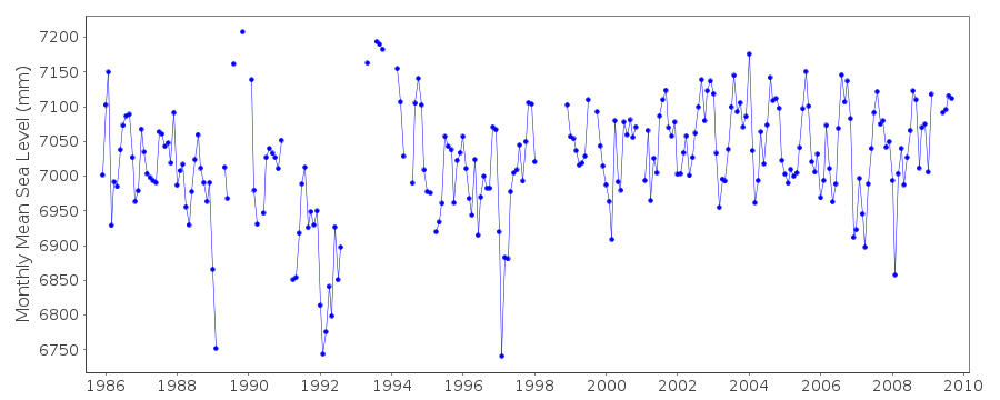
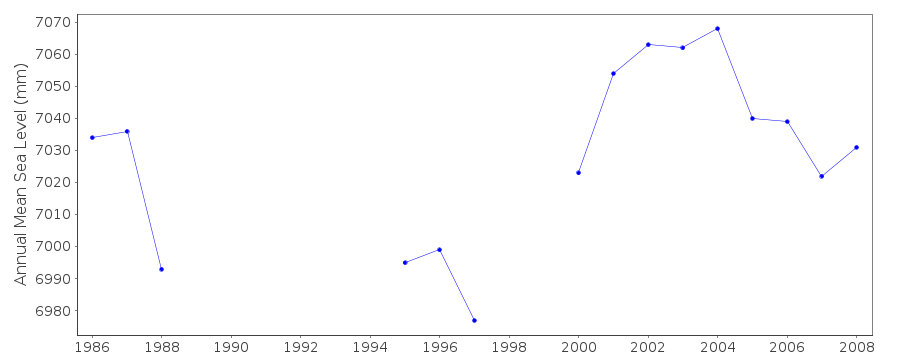
| Time span of data: | 1985 – 2009 |
| Completeness (%): | 80 |
| Date of last update: | 09 Jul 2013 |
| Green Arrow: | Current Station |
| Yellow Marker: | Neighbouring RLR Station |
| Red Marker: | Neighbouring Metric Station |
Please note: In many cases, the station position in our database is accurate to only one minute. Thus, the tide gauge may not appear to be on the coast.
Tide Gauge Data
Additional Data Sources (guide to additional data sources)
Nearby Real Time Stations from VLIZ: bodrStation Documentation
Link to RLR information.Documentation added 1995-06-05
1992 revised, June 1995Documentation added 1999-09-03
Acoustic gauge (Aquatrak 4100 series sensor) installed in 1998Documentation added 2000-06-05
New analogue chart, float gauges were installed in 1985 in 4 Turkishstations: Antalya II, Bodrum II, Metes/Izmir and Erdek. All were
replaced by new acoustic systems in 1998-99.
Documentation added 2000-06-05
Bodrum II 310/046 RLR(1986) is 8.608m below BM MAR 1Documentation added 2010-07-01
During May 2010 the complete revised data holding from the Turkish Sea LevelMonitoring Network were supplied to the PSMSL from the General Command of
Mapping.All datasets including that for Bodrum II were replaced. Previously RLR
the values were TGBM BM MARI 3.475m above Chart Datum. RLR (1986) 8.608m below
TGBM BM MARI. RLR factor 6.0m.
A revised RLR diagram was created with Primary Benchmarl BDRM-1 2.578m above
TGZ.
RLR (2008) 8.3m below TGBM BDRM-1. RLR factor 5.722m
Add 5.722m to all data values to refer to RLR (2008).
There also exists a secondary benchmark BDRM-2. This is 2.407m above TGZ.
Data Authority
General Directorate of MappingTlp Fakultesi Cad
06590 Cebeci/Cankaya
Ankara

![]()
![]()
![]()
