Data
- Obtaining
- Supplying
- High-Frequency
- Bottom Pressure Records
- Other Long Records
- GLOSS/ODINAFRICA Calibration Data
Donate
Donate to PSMSL
Data Notes
- Individual Station Data and Plot Notes
- Referencing the Data Set
- PSMSL Help File
- 2010 Changes to the PSMSL Data Files
Extracted from Database
20 Jul 2026
Station Information
| Station ID: | 1671 |
| Latitude: | 24.332222 |
| Longitude: | 124.163611 |
| Coastline code: | 646 |
| Station code: | 42 |
| Country: | JAPAN |
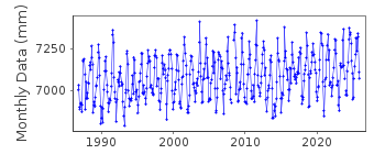
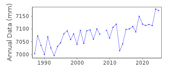
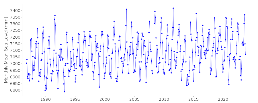
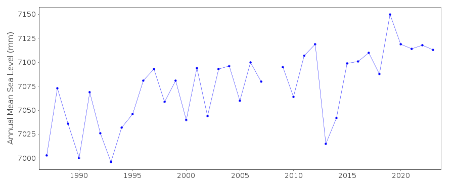
| Time span of data: | 1986 – 2025 |
| Completeness (%): | 97 |
| Date of last update: | 08 Apr 2026 |
| Green Arrow: | Current Station |
| Yellow Marker: | Neighbouring RLR Station |
| Red Marker: | Neighbouring Metric Station |
Please note: In many cases, the station position in our database is accurate to only one minute. Thus, the tide gauge may not appear to be on the coast.
Tide Gauge Data
Additional Data Sources (guide to additional data sources)
Nearby GNSS Stations from SONEL: ISHINearby Real Time Stations from VLIZ: ishig
Fast Delivery Data from UHSLC station 365: hourly and daily
Research Quality Data from UHSLC station 365: hourly and daily
Station Documentation
Link to RLR information.Documentation added 2001-02-23
Ishigaki II 646/042 RLR(1993) is 9.7m below Attached BMDocumentation added 2002-03-26
Ishigaki gauge replaced June 1979.Documentation added 2002-03-26
Ishigaki II replaced Ishigaki (646/041) 1st October 1986.Documentation added 2012-02-22
A massive earthquake of magnitude 9.0 occurred at 14.46 JST (05.46 UTC) on Friday 11th March 2011 with the epicentre situated approx. 70km east of the Oshika Penisula of Tohoku. The earthquake was the largest ever to hit Japan and triggered a tsunami with waves of up to 40.5m which travelled up to 10km inland.Data Authority
Japan Meteorological Agency3-6-9 Toranomon, Minato City
Tokyo

![]()
![]()
![]()
