Data
- Obtaining
- Supplying
- High-Frequency
- Bottom Pressure Records
- Other Long Records
- GLOSS/ODINAFRICA Calibration Data
Donate
Donate to PSMSL
Data Notes
- Individual Station Data and Plot Notes
- Referencing the Data Set
- PSMSL Help File
- 2010 Changes to the PSMSL Data Files
Extracted from Database
13 Jul 2026
Station Information
| Station ID: | 1600 |
| Latitude: | -6.15 |
| Longitude: | 39.183333 |
| GLOSS ID: | 297 |
| Coastline code: | 460 |
| Station code: | 16 |
| Country: | TANZANIA, UNITED REPUBLIC OF |
| Time span of data: | 1984 – 2018 |
| Completeness (%): | 96 |
| Date of last update: | 29 Jan 2020 |
| Green Arrow: | Current Station |
| Yellow Marker: | Neighbouring RLR Station |
| Red Marker: | Neighbouring Metric Station |
Please note: In many cases, the station position in our database is accurate to only one minute. Thus, the tide gauge may not appear to be on the coast.
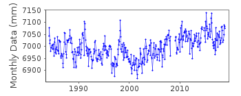
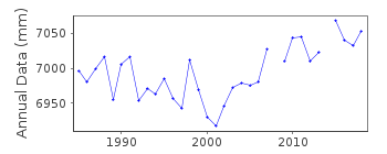
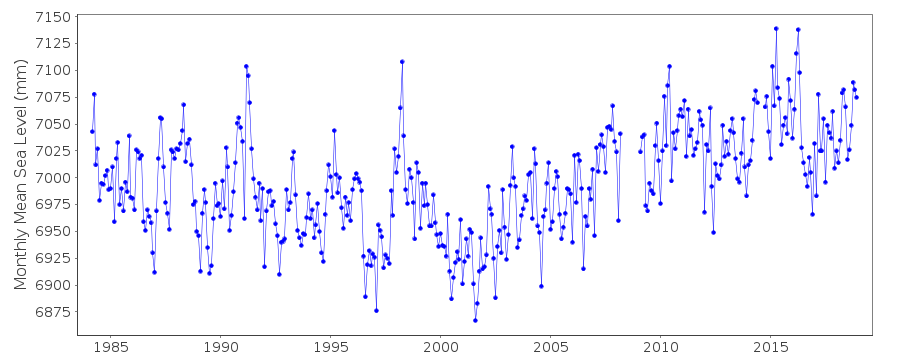
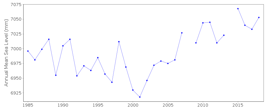
Tide Gauge Data
Additional Data Sources (guide to additional data sources)
Nearby GNSS Stations from SONEL: ZNZBFast Delivery Data from UHSLC station 151: hourly and daily
Research Quality Data from UHSLC station 151: hourly and daily
Station Documentation
Link to RLR information.Documentation added 1991-06-11
Zanzibar 460/016 RLR(1986) is 10.8m below TGBMDocumentation added 1996-10-16
data 1994 onwards received from UH SLC instrument: Float type, R.W. Munro, London, I.H. 109Documentation added 1997-09-22
In addition to the Munro gauge there is a Handar 463 SDI 12 encoder connected to a Handar 540 satellite DCP platformDocumentation added 2001-03-22
Data for 1984-99 revised March 2001Documentation added 2012-01-18
Using data extracted from the latest UHSLC JASL cd data values for 2005/6 have been added.Documentation added 2013-10-15
Complete UHSLC dataset 1984-2012 loaded into the series. Data has been supplied by UHSLC throughout.Documentation added 2015-11-03
Updated JASL data 2009-2014 loaded onto the database. UHSLC metadata says 2015 JASL update replaces 2009-2012 data for level adjustments. Station supplier has also been updated from Comm. for Lands and Environment to UHSLC.Data Authority
University of Hawaii Sea Level CenterDepartment of Oceanography Division of Natural Sciences
1000 Pope Road
Honolulu
Hawaii 96822

![]()
![]()
![]()
