Data
- Obtaining
- Supplying
- High-Frequency
- Bottom Pressure Records
- Other Long Records
- GLOSS/ODINAFRICA Calibration Data
Donate
Donate to PSMSL
Data Notes
- Individual Station Data and Plot Notes
- Referencing the Data Set
- PSMSL Help File
- 2010 Changes to the PSMSL Data Files
Extracted from Database
13 Jul 2026
Station Information
| Station ID: | 1598 |
| Latitude: | 40.383333 |
| Longitude: | 27.85 |
| Coastline code: | 310 |
| Station code: | 38 |
| Country: | TÜRKİYE |
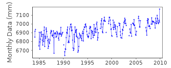
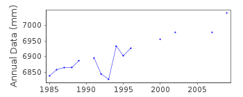
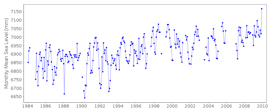
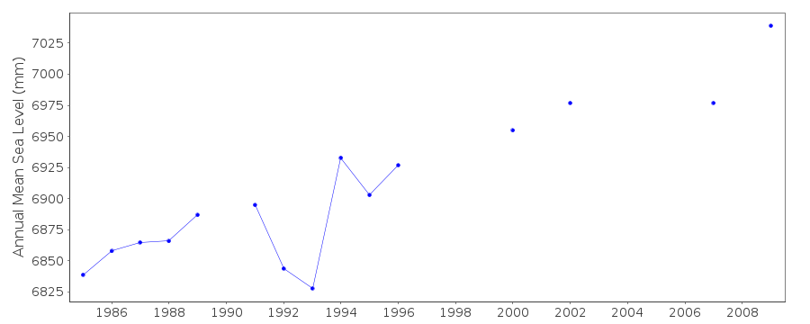
| Time span of data: | 1984 – 2009 |
| Completeness (%): | 82 |
| Date of last update: | 09 Jul 2013 |
| Green Arrow: | Current Station |
| Yellow Marker: | Neighbouring RLR Station |
| Red Marker: | Neighbouring Metric Station |
Please note: In many cases, the station position in our database is accurate to only one minute. Thus, the tide gauge may not appear to be on the coast.
Tide Gauge Data
Additional Data Sources (guide to additional data sources)
Nearby Real Time Stations from VLIZ: erdekStation Documentation
Link to RLR information.Documentation added 1999-09-03
Acoustic gauge (Aquatrak 4100 series sensor) installed in April 1999Documentation added 2000-06-05
New analogue chart, float gauges were installed in 1985 in 4 Turkishstations: Antalya II, Bodrum II, Metes/Izmir and Erdek. All were
replaced by new acoustic systems in 1998-99.
Documentation added 2000-06-05
Erdek 310/038 RLR(1995) is 8.561m below BM MAR 1Documentation added 2010-06-28
Erdek is on the Sea of Marmara. This station forms part of the Turkish Sea LevelMonitoring Network.The total dataset has been revised by the authority.
A new RLR diagram has been created. Coast/Station code 310/038 id=1598. RLR
(2009) is 7.700m below TGBM
ERDK-1. RLR factor is 5.110m.
Data Authority
General Directorate of MappingTlp Fakultesi Cad
06590 Cebeci/Cankaya
Ankara

![]()
![]()
![]()
