Data
- Obtaining
- Supplying
- High-Frequency
- Bottom Pressure Records
- Other Long Records
- GLOSS/ODINAFRICA Calibration Data
Donate
Donate to PSMSL
Data Notes
- Individual Station Data and Plot Notes
- Referencing the Data Set
- PSMSL Help File
- 2010 Changes to the PSMSL Data Files
Extracted from Database
20 Jul 2026
Station Information
| Station ID: | 1577 |
| Latitude: | 44.083333 |
| Longitude: | 15.266667 |
| Coastline code: | 280 |
| Station code: | 14 |
| Country: | CROATIA |
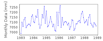
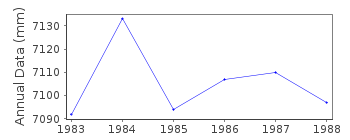
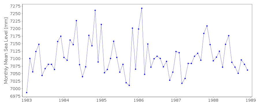
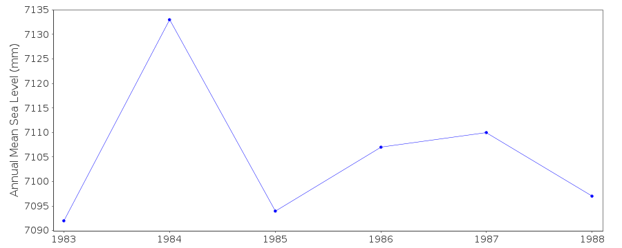
| Time span of data: | 1983 – 1988 |
| Completeness (%): | 100 |
| Date of last update: | 31 May 1990 |
| Green Arrow: | Current Station |
| Yellow Marker: | Neighbouring RLR Station |
| Red Marker: | Neighbouring Metric Station |
Please note: In many cases, the station position in our database is accurate to only one minute. Thus, the tide gauge may not appear to be on the coast.
Tide Gauge Data
Station Documentation
Link to RLR information.Documentation added 1991-06-11
Gazenica 280/014 RLR(1985) is 10.1m below BMDocumentation added 1993-07-12
Gazenica 280/014 RLR(1985) is 10.1m below BMDocumentation added 1996-01-12
gauge discontinued 10 January 1989Documentation added 2011-01-20
Span of data for Gazenica Jan 1983 - Dec 1988. RLR factor 6.423m . Diagramupdated
for new website.
Data Authority
Hidrografski Institut JrmSplit
Documentation added 1993-10-05
SEE AUTHORITY E1

![]()
![]()
![]()
