Data
- Obtaining
- Supplying
- High-Frequency
- Bottom Pressure Records
- Other Long Records
- GLOSS/ODINAFRICA Calibration Data
Donate
Donate to PSMSL
Data Notes
- Individual Station Data and Plot Notes
- Referencing the Data Set
- PSMSL Help File
- 2010 Changes to the PSMSL Data Files
Extracted from Database
20 Jul 2026
Station Information
| Station ID: | 1513 |
| Latitude: | 38.866667 |
| Longitude: | 121.683333 |
| GLOSS ID: | 79 |
| Coastline code: | 610 |
| Station code: | 45 |
| Country: | CHINA |
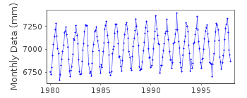
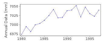
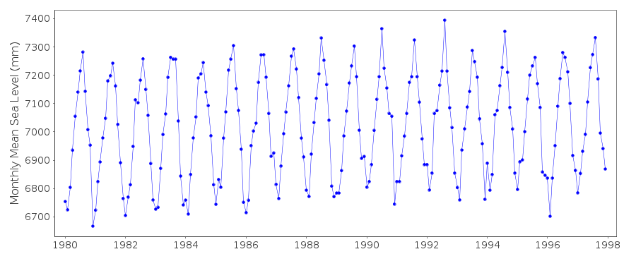
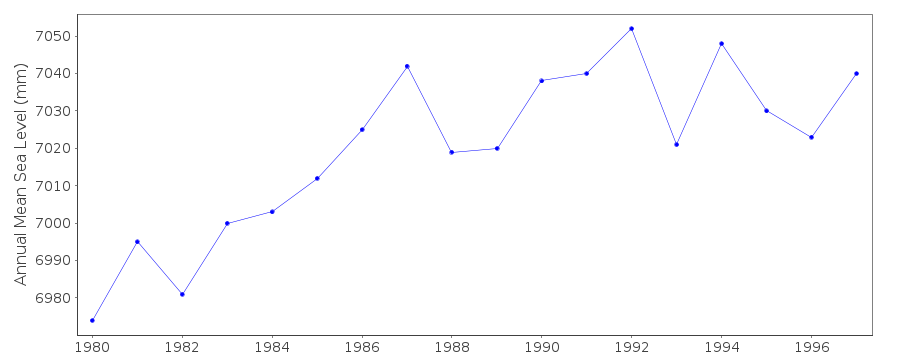
| Time span of data: | 1980 – 1997 |
| Completeness (%): | 100 |
| Date of last update: | 20 Apr 1998 |
| Green Arrow: | Current Station |
| Yellow Marker: | Neighbouring RLR Station |
| Red Marker: | Neighbouring Metric Station |
Please note: In many cases, the station position in our database is accurate to only one minute. Thus, the tide gauge may not appear to be on the coast.
Tide Gauge Data
Additional Data Sources (guide to additional data sources)
Research Quality Data from UHSLC station 630: hourly and dailyResearch Quality Data from UHSLC station 631: hourly and daily
Station Documentation
Link to RLR information.Documentation added 1998-04-21
data 1993-94 revised with dataset received in April 1998Documentation added 1999-10-29
Laohutan was formerly known as Port Arthur and is actually the same as Dalian.Data Authority
National Marine Data and Information Service (NMDIS)No. 93 Liuwei Road
Tianjin 300171

![]()
![]()
![]()
