Data
- Obtaining
- Supplying
- High-Frequency
- Bottom Pressure Records
- Other Long Records
- GLOSS/ODINAFRICA Calibration Data
Donate
Donate to PSMSL
Data Notes
- Individual Station Data and Plot Notes
- Referencing the Data Set
- PSMSL Help File
- 2010 Changes to the PSMSL Data Files
Extracted from Database
13 Jul 2026
Station Information
| Station ID: | 1505 |
| Latitude: | 54.49 |
| Longitude: | -0.614694 |
| Coastline code: | 170 |
| Station code: | 56 |
| Country: | UNITED KINGDOM |
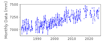
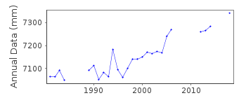
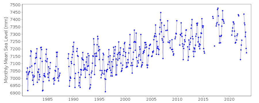
| Time span of RLR data: | 1981 – 2025 |
| RLR completeness (%): | 79 |
| Time span of metric data: | 1980 – 2025 |
| Metric completeness (%): | 79 |
| Date of last update: | 19 Feb 2026 |
| Green Arrow: | Current Station |
| Yellow Marker: | Neighbouring RLR Station |
| Red Marker: | Neighbouring Metric Station |
Please note: In many cases, the station position in our database is accurate to only one minute. Thus, the tide gauge may not appear to be on the coast.
Tide Gauge Data
Additional Data Sources (guide to additional data sources)
Nearby Real Time Stations from VLIZ: whitStation Documentation
Link to RLR information.Documentation added 1993-03-17
WHITBY RLR(1991):12.9M BELOW TGBM JULY 1987-APRIL 1988 Deleted - Datum Suspect, Support Structure MissingDocumentation added 1993-07-12
Whitby 170/056 RLR(1991) is 12.9m below TGBMDocumentation added 1994-07-21
Whitby had an Aanderaa pressure system gauge from 1980, replaced in April 1989 by an "A Class" bubbler.Documentation added 2001-01-02
Recent work on vertical land movements in the UK can be found from the University of Nottingham web site: http://ukcogr.iessg.nottingham.ac.uk/~eosi/Documentation added 2006-11-15
Historic tide gauge information: Through the early 1990s thereDocumentation added 2006-11-15
Historic tide gauge information.Through the early 1990s there were several problems at site. Pressure pipes were crushed new pipes fitted February 1993. November 1994 pressure point mounts dropped.Documentation added 2006-11-15
March 1995 new steelwork fitted and site re-levelled. March 2002 new datalogger fitted. There is a general unexplained upward trend at site. The site also has a density problem due to river flow.Documentation added 2009-01-28
Treat as suspect 1997 data onwards.Documentation added 2012-05-24
Primary benchmark is NZ 8986 1141 9.105m above TGZ.Documentation added 2014-07-04
There were several visits to Whitby during 2013. In March during data processing it was noted that the gauge was recording flat low waters. On 14.05.2013 TGI were on site to carry out general maintenance and change the compressor. They returned on 22.05.2013 to carry out a mid-tide survey and measurements using a pilot boat. During June 2013 the primary channel was recording ~40mm high. TGI returned to the site on 14.11.2013 to attend a site meeting to discuss network electrical installations.Documentation added 2015-06-02
The gauge was recording flat low waters through February and again through July, August and September. TGI were at site several times. 29.01.14 to change the compressor, 19.05.14 for General maintenance, 05.06.14 for a meeting with the harbour master and site survey to discuss re-development of the tide gauge area and 15.12.14 to replace a faulty outstation.Data Authority
Environment AgencyHorizon House
Deanery Road
BS1 5AH
Bristol

![]()
![]()
![]()
