Data
- Obtaining
- Supplying
- High-Frequency
- Bottom Pressure Records
- Other Long Records
- GLOSS/ODINAFRICA Calibration Data
Donate
Donate to PSMSL
Data Notes
- Individual Station Data and Plot Notes
- Referencing the Data Set
- PSMSL Help File
- 2010 Changes to the PSMSL Data Files
Extracted from Database
13 Jul 2026
Station Information
| Station ID: | 1501 |
| Latitude: | -20.934924 |
| Longitude: | 55.285005 |
| GLOSS ID: | 17 |
| Coastline code: | 451 |
| Station code: | 1 |
| Country: | RÉUNION |
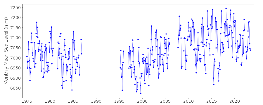
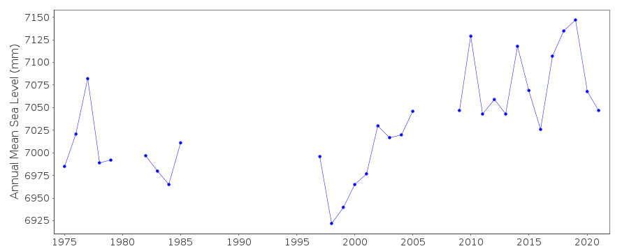
| Time span of RLR data: | 1967 – 2025 |
| RLR completeness (%): | 59 |
| Time span of metric data: | 1967 – 2025 |
| Metric completeness (%): | 62 |
| Date of last update: | 20 Feb 2026 |
| Green Arrow: | Current Station |
| Yellow Marker: | Neighbouring RLR Station |
| Red Marker: | Neighbouring Metric Station |
Please note: In many cases, the station position in our database is accurate to only one minute. Thus, the tide gauge may not appear to be on the coast.
Tide Gauge Data
Additional Data Sources (guide to additional data sources)
Nearby GNSS Stations from SONEL: LEPONearby Real Time Stations from VLIZ: reun, reun2
Fast Delivery Data from UHSLC station 164: hourly and daily
Research Quality Data from UHSLC station 164: hourly and daily
Station Documentation
Link to RLR information.Documentation added 1991-06-11
Pointe des Galets 451/001 RLR(1979) is 9.5m below Repere ADocumentation added 2010-08-24
Tide gauge was re-instated in 2007. Previous TGBM was BM A 3.0m above Chart Datum. TGBM is now IGN AMO 2.809m above Chart Datum. Chart Datum has remained the same as confirmed by Ronan Creach email of 19.08.10. Therefore RLR factor remains 6.500m.Documentation added 2012-03-28
Now that there are several years of data for Pointe des Galets following its re-installation the data 2007 onwards appears to be higher than previously. Because of its remote location it is difficult to confirm this one way or the other.Documentation added 2014-09-24
Using values from the SONEL website the latitude and longitude for Pointe des Galets have been revised. The data downloaded from SONEL included additional data for the 1960's and 2000's. These have been added to the database.Documentation added 2025-07-15
Updated the whole dataset to ensure they include all the historical data recovered recently by SHOM and the calculated monthly and annual means match those distributed by SONEL.Data Authority
SHOM13 rue de Chatelier
29200 BREST

![]()
![]()
![]()
