Data
- Obtaining
- Supplying
- High-Frequency
- Bottom Pressure Records
- Other Long Records
- GLOSS/ODINAFRICA Calibration Data
Donate
Donate to PSMSL
Data Notes
- Individual Station Data and Plot Notes
- Referencing the Data Set
- PSMSL Help File
- 2010 Changes to the PSMSL Data Files
Extracted from Database
13 Jul 2026
Station Information
| Station ID: | 1494 |
| Latitude: | 26.233333 |
| Longitude: | 50.6 |
| Coastline code: | 482 |
| Station code: | 19 |
| Country: | BAHRAIN |
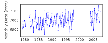
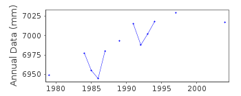
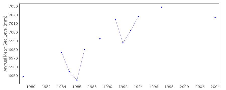
| Time span of data: | 1979 – 2007 |
| Completeness (%): | 66 |
| Date of last update: | 17 Jan 2012 |
| Green Arrow: | Current Station |
| Yellow Marker: | Neighbouring RLR Station |
| Red Marker: | Neighbouring Metric Station |
Please note: In many cases, the station position in our database is accurate to only one minute. Thus, the tide gauge may not appear to be on the coast.
Tide Gauge Data
Additional Data Sources (guide to additional data sources)
Nearby GNSS Stations from SONEL: BHR2, BAHR, BHR3, BHR4, BHR1Research Quality Data from UHSLC station 182: hourly and daily
Station Documentation
Link to RLR information.Documentation added 1996-10-16
instrument: OTT mechanical float/wellDocumentation added 2007-07-18
data throughout received from UH Sea Level CenterDocumentation added 2007-07-19
Mean Sea Level values are received from the University of Hawaii Sea Level Centre.Documentation added 2012-01-18
Using data values extracted from the latest UHSLC JASL cd data for 2006/7 have been added to the database.Data Authority
Survey DirectorateMinistry of Housing
P.O. Box 5802
Manama

![]()
![]()
![]()
