Data
- Obtaining
- Supplying
- High-Frequency
- Bottom Pressure Records
- Other Long Records
- GLOSS/ODINAFRICA Calibration Data
Donate
Donate to PSMSL
Data Notes
- Individual Station Data and Plot Notes
- Referencing the Data Set
- PSMSL Help File
- 2010 Changes to the PSMSL Data Files
Extracted from Database
22 Jun 2026
Station Information
| Station ID: | 1491 |
| Latitude: | 56.623111 |
| Longitude: | -6.064222 |
| Coastline code: | 170 |
| Station code: | 246 |
| Country: | UNITED KINGDOM |
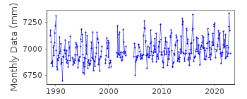
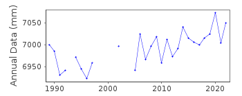
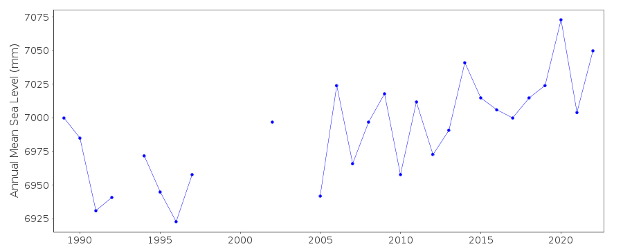
| Time span of RLR data: | 1989 – 2023 |
| RLR completeness (%): | 88 |
| Time span of metric data: | 1979 – 2023 |
| Metric completeness (%): | 71 |
| Date of last update: | 19 Feb 2026 |
| Green Arrow: | Current Station |
| Yellow Marker: | Neighbouring RLR Station |
| Red Marker: | Neighbouring Metric Station |
Please note: In many cases, the station position in our database is accurate to only one minute. Thus, the tide gauge may not appear to be on the coast.
Tide Gauge Data
Additional Data Sources (guide to additional data sources)
Nearby Real Time Stations from VLIZ: tobeStation Documentation
Link to RLR information.Documentation added 1991-06-11
Tobermory 170/246 RLR(1990) is 11.1m below TGBM NM 5069 5530Documentation added 1994-07-20
An Ott stilling well gauge installed in 1979, replaced by an "A Class" bubbler system in August 1987.Documentation added 2001-01-02
Recent work on vertical land movements in the UK can be found from the University of Nottingham web site:http://ukcogr.iessg.nottingham.ac.uk/~eosi/Documentation added 2014-07-04
There were several visits to Tobermory by TGI during 2013. 26.03.2013 visit to carry out general maintenance and replace faulty power supply. 29.08.2013 again the carry out general maintenance but this time to carry out diving maintenance as well and finally 15.10.2013 when new support clamps were installed.Documentation added 2015-06-02
TGI visited the site twice during 2014 07/02/14 to change the compressor and again 01/07/14 for General maintenance.Documentation added 2015-12-03
This station was previously flagged. This station flag has now been removed.Data Authority
Environment AgencyHorizon House
Deanery Road
BS1 5AH
Bristol

![]()
![]()
![]()
