Data
- Obtaining
- Supplying
- High-Frequency
- Bottom Pressure Records
- Other Long Records
- GLOSS/ODINAFRICA Calibration Data
Donate
Donate to PSMSL
Data Notes
- Individual Station Data and Plot Notes
- Referencing the Data Set
- PSMSL Help File
- 2010 Changes to the PSMSL Data Files
Extracted from Database
13 Jul 2026
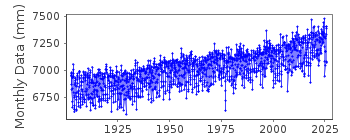
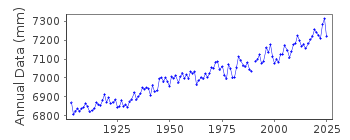
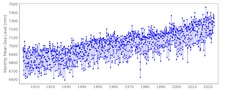
Station Information
| Station ID: | 148 |
| Latitude: | 39.266667 |
| Longitude: | -76.578333 |
| Coastline code: | 960 |
| Station code: | 81 |
| Country: | UNITED STATES |
| Time span of data: | 1902 – 2025 |
| Completeness (%): | 99 |
| Date of last update: | 27 Jan 2026 |
| Green Arrow: | Current Station |
| Yellow Marker: | Neighbouring RLR Station |
| Red Marker: | Neighbouring Metric Station |
Please note: In many cases, the station position in our database is accurate to only one minute. Thus, the tide gauge may not appear to be on the coast.
Tide Gauge Data
Additional Data Sources (guide to additional data sources)
Nearby GNSS Stations from SONEL: SA15, UMBCNearby Real Time Stations from VLIZ: bamd
Station Documentation
Link to RLR information.Documentation added 1991-06-11
Baltimore 960/081 RLR(1964) is 8.2m below BM1Documentation added 1993-07-29
Low values in early 1977 are probably correct - for example, compare to 960/080 Annapolis. These values were flagged but because the data compares well with Annapolis the flags have been removed.Documentation added 2011-08-22
Using NOAA data the RLR diagram has been updated. Primary benchmark is now 32 1922 3.158m above the gauge datum. The previous benchmark BM1 does not appear in the current NOAA report dated 21.4.2003 or the previous report of 28.3.1988.Data Authority
N.O.A.A. / N.O.S.N/oes33, Ssmc4, Room 6531
1305 East-West Highway
Silver Spring,
MD 20910

![]()
![]()
![]()
