Data
- Obtaining
- Supplying
- High-Frequency
- Bottom Pressure Records
- Other Long Records
- GLOSS/ODINAFRICA Calibration Data
Donate
Donate to PSMSL
Data Notes
- Individual Station Data and Plot Notes
- Referencing the Data Set
- PSMSL Help File
- 2010 Changes to the PSMSL Data Files
Extracted from Database
13 Jul 2026
Station Information
| Station ID: | 1475 |
| Latitude: | 16.1 |
| Longitude: | 108.216667 |
| Coastline code: | 605 |
| Station code: | 51 |
| Country: | VIET NAM |
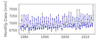
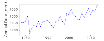
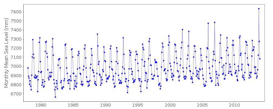
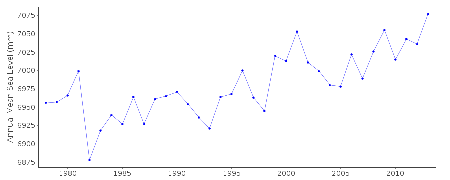
| Time span of data: | 1978 – 2013 |
| Completeness (%): | 100 |
| Date of last update: | 17 Nov 2015 |
| Green Arrow: | Current Station |
| Yellow Marker: | Neighbouring RLR Station |
| Red Marker: | Neighbouring Metric Station |
Please note: In many cases, the station position in our database is accurate to only one minute. Thus, the tide gauge may not appear to be on the coast.
Tide Gauge Data
Station Documentation
Link to RLR information.Documentation added 1999-02-23
Gauge type: 1977 - March 1992 = Russian type, CYM and from April 1992 onwards = American type, Stevens A71 Danang is now an historic station last data 2001Documentation added 2015-11-17
Monthly mean sea leve data values for Da Nang 2001-2013 have been supplied by the Institute of Meteorology, Hydrology and Climate Change (IMHEN) Viet nam.Data Authority
Marine Hydrometeorological CentreHydro-meteorological and Environmental
Station Network Center
No. 62 Nguyen Chi Thanh Street
Dong Da
Hanoi

![]()
![]()
![]()
