Data
- Obtaining
- Supplying
- High-Frequency
- Bottom Pressure Records
- Other Long Records
- GLOSS/ODINAFRICA Calibration Data
Donate
Donate to PSMSL
Data Notes
- Individual Station Data and Plot Notes
- Referencing the Data Set
- PSMSL Help File
- 2010 Changes to the PSMSL Data Files
Extracted from Database
13 Jul 2026
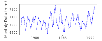
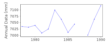
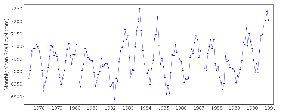
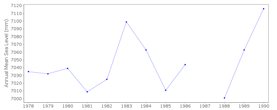
Station Information
| Station ID: | 1457 |
| Latitude: | 30.483333 |
| Longitude: | -115.983333 |
| Coastline code: | 830 |
| Station code: | 5 |
| Country: | MEXICO |
| Time span of data: | 1977 – 1990 |
| Completeness (%): | 93 |
| Date of last update: | 29 Dec 1994 |
| Green Arrow: | Current Station |
| Yellow Marker: | Neighbouring RLR Station |
| Red Marker: | Neighbouring Metric Station |
Please note: In many cases, the station position in our database is accurate to only one minute. Thus, the tide gauge may not appear to be on the coast.
Tide Gauge Data
Additional Data Sources (guide to additional data sources)
Research Quality Data from UHSLC station 308: hourly and dailyStation Documentation
Link to RLR information.Documentation added 1991-06-11
Bahia San Quintin 830/005 RLR(1981) is 8.7m below BM1Documentation added 1992-02-06
DATA 1982-89 RECEIVED FROM TOGA OFFICEDocumentation added 1993-07-12
Bahia San Quintin 830/005 RLR(1981) is 8.7m below BM1Documentation added 1995-01-10
data 1990 received from TOGA officeThis is now an historic station last data 1990
Documentation added 1997-01-30
Large earthquake offshore of Mexico about 19 degrees North on9 October 1995 with large tsunami generated. See article by
A.E.Filonov in EOS, 78(3), 1997.
Data Authority
C.I.C.E.S.E.P.O. Box 434844
San Diego
CA 92143-4844

![]()
![]()
![]()
