Data
- Obtaining
- Supplying
- High-Frequency
- Bottom Pressure Records
- Other Long Records
- GLOSS/ODINAFRICA Calibration Data
Donate
Donate to PSMSL
Data Notes
- Individual Station Data and Plot Notes
- Referencing the Data Set
- PSMSL Help File
- 2010 Changes to the PSMSL Data Files
Extracted from Database
13 Jul 2026
Station Information
| Station ID: | 1455 |
| Latitude: | 36.829231 |
| Longitude: | -2.457131 |
| Coastline code: | 220 |
| Station code: | 41 |
| Country: | SPAIN |
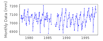
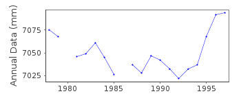
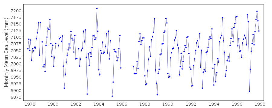
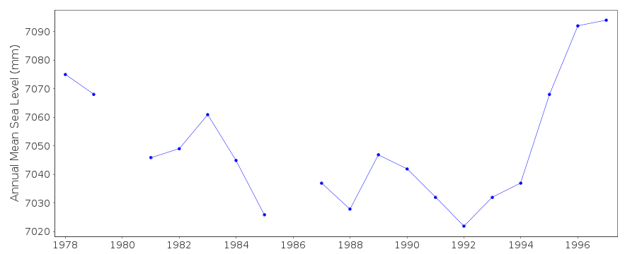
| Time span of data: | 1977 – 1997 |
| Completeness (%): | 89 |
| Link to ellipsoid: | Available |
| Date of last update: | 11 Nov 1998 |
| Green Arrow: | Current Station |
| Yellow Marker: | Neighbouring RLR Station |
| Red Marker: | Neighbouring Metric Station |
Please note: In many cases, the station position in our database is accurate to only one minute. Thus, the tide gauge may not appear to be on the coast.
Tide Gauge Data
Additional Data Sources (guide to additional data sources)
Nearby GNSS Stations from SONEL: ALM1, ALMENearby Real Time Stations from VLIZ: alme, alme2
Station Documentation
Link to RLR information.Documentation added 1994-01-12
data revised January 1994. 1977 - 1985 (January) from Playa San Miguel(36 50 N 02 27 W); 1985 (March) - 1991 from Puerto Pesquero
(36 50 N 02 29 W).
Documentation added 1997-02-17
1991 revised, February 1997Almeria is an historic station last data is 1997
Data Authority
Instituto Geográfico NacionalRed de Infraestructuras Geodésicas
General Ibáñez de Ibero, 3
28003, Madrid

![]()
![]()
![]()
