Data
- Obtaining
- Supplying
- High-Frequency
- Bottom Pressure Records
- Other Long Records
- GLOSS/ODINAFRICA Calibration Data
Donate
Donate to PSMSL
Data Notes
- Individual Station Data and Plot Notes
- Referencing the Data Set
- PSMSL Help File
- 2010 Changes to the PSMSL Data Files
Extracted from Database
20 Jul 2026
Station Information
| Station ID: | 1441 |
| Latitude: | 38.460889 |
| Longitude: | 23.589458 |
| Coastline code: | 290 |
| Station code: | 33 |
| Country: | GREECE |
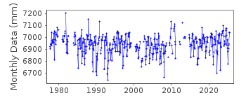
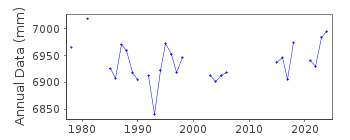
| Time span of data: | 1977 – 2025 |
| Completeness (%): | 78 |
| Date of last update: | 13 Mar 2026 |
| Green Arrow: | Current Station |
| Yellow Marker: | Neighbouring RLR Station |
| Red Marker: | Neighbouring Metric Station |
Please note: In many cases, the station position in our database is accurate to only one minute. Thus, the tide gauge may not appear to be on the coast.
Tide Gauge Data
Station Documentation
Link to RLR information.Documentation added 1991-06-11
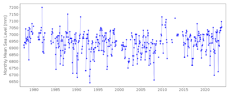
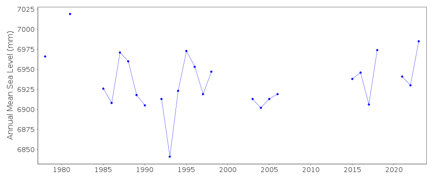
Khalkis South 290/033 RLR(1978) is 9.3m below BM R60Documentation added 1997-03-11
The contributing authority advises that anomalous valuesare the result of met. influences
Documentation added 1997-03-11
values for December 1987 and December 1990 affected by missing dataDocumentation added 2006-11-28
Whole dataset flagged due to unresolved datum query.Documentation added 2011-07-13
Following further information from the Hellenic Navy Hydrographic Service thedata for Khalkis South were adjusted. Plotted data now appears correct.
Therefore the station flag has been removed and the station reverted to RLR
status. The RLR diagram has been redrawn to include the adjustments.
Documentation added 2013-08-12
following receipt of datum diagrams from the Hellenic Navy the RLR diagram has been re-drawn. In consequence the RLR factors have changed.Data Authority
Hellenic Navy Hydrographic ServiceGeographic Policy and International Relations Office
TGN 1040
Athens

![]()
![]()
![]()
