Data
- Obtaining
- Supplying
- High-Frequency
- Bottom Pressure Records
- Other Long Records
- GLOSS/ODINAFRICA Calibration Data
Donate
Donate to PSMSL
Data Notes
- Individual Station Data and Plot Notes
- Referencing the Data Set
- PSMSL Help File
- 2010 Changes to the PSMSL Data Files
Extracted from Database
13 Jul 2026
Station Information
| Station ID: | 1437 |
| Latitude: | 34.806944 |
| Longitude: | 138.764167 |
| Coastline code: | 642 |
| Station code: | 119 |
| Country: | JAPAN |
| Time span of RLR data: | 1981 – 2025 |
| RLR completeness (%): | 97 |
| Time span of metric data: | 1977 – 2025 |
| Metric completeness (%): | 96 |
| Link to ellipsoid: | Available |
| Date of last update: | 08 Apr 2026 |
| Green Arrow: | Current Station |
| Yellow Marker: | Neighbouring RLR Station |
| Red Marker: | Neighbouring Metric Station |
Please note: In many cases, the station position in our database is accurate to only one minute. Thus, the tide gauge may not appear to be on the coast.
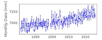
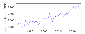
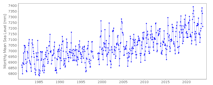
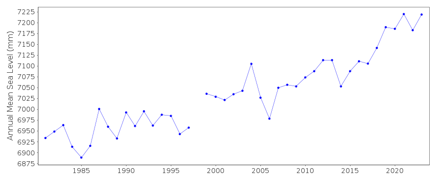
Tide Gauge Data
Station Documentation
Link to RLR information.Documentation added 1991-06-11
Tago 642/119 RLR(1983) is 11.6m below BM Attach-31Documentation added 2009-05-05
Data 1999 onwards appears to be slightly higher than previously.Documentation added 2012-02-22
A massive earthquake magnitude 9.0 occurred at 14.46 JTS (05.46 UTC) on Friday 11th March 2011 with the epicentre situated approx. 70km east of the Oshika Peninsula of Tohoku. It was the largest earthquake ever to hit Japan triggering a tsunami with waves of up to 40.5m and travelling up to 10km inland.Documentation added 2014-03-13
The GPS benchmark information has been downloaded from the SONEL website. GPS benchmark P114 is 14.073m above RLR.Data Authority
Geographical Survey InstituteKitasato -1
Tsukuba-shi
Ibaraki-ken 305

![]()
![]()
![]()
