Data
- Obtaining
- Supplying
- High-Frequency
- Bottom Pressure Records
- Other Long Records
- GLOSS/ODINAFRICA Calibration Data
Donate
Donate to PSMSL
Data Notes
- Individual Station Data and Plot Notes
- Referencing the Data Set
- PSMSL Help File
- 2010 Changes to the PSMSL Data Files
Extracted from Database
13 Jul 2026
Station Information
| Station ID: | 1421 |
| Latitude: | 78.928545 |
| Longitude: | 11.938015 |
| GLOSS ID: | 345 |
| Coastline code: | 25 |
| Station code: | 21 |
| Country: | SVALBARD AND JAN MAYEN |
| Time span of RLR data: | 1976 – 2025 |
| RLR completeness (%): | 89 |
| Time span of metric data: | 1976 – 2025 |
| Metric completeness (%): | 95 |
| Date of last update: | 30 Jan 2026 |
| Green Arrow: | Current Station |
| Yellow Marker: | Neighbouring RLR Station |
| Red Marker: | Neighbouring Metric Station |
Please note: In many cases, the station position in our database is accurate to only one minute. Thus, the tide gauge may not appear to be on the coast.
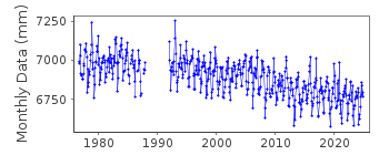
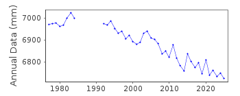
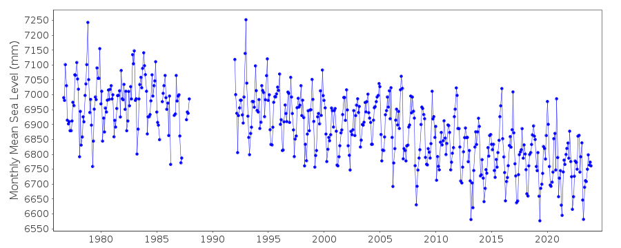
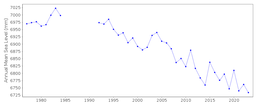
Tide Gauge Data
Additional Data Sources (guide to additional data sources)
Nearby GNSS Stations from SONEL: NABG, NYA2, NYA1, NYAL, NYACNearby Real Time Stations from VLIZ: nyal
Fast Delivery Data from UHSLC station 823: hourly and daily
Research Quality Data from UHSLC station 823: hourly and daily
Station Documentation
Link to RLR information.Documentation added 1995-03-30
tide gauge network modernised, new equipment installed in 1992Documentation added 2012-09-05
For information on sea level change along the Norwegian coast see paper"Contributions to sea level variability along the Norwegian coast for 1960-2010"
by K. Richter, J.E.O. Nilsen and H. Drange.
Data Authority
Norwegian Mapping AuthorityHydrographic Service
Po. Box 60
4001 Stavanger

![]()
![]()
![]()
