Data
- Obtaining
- Supplying
- High-Frequency
- Bottom Pressure Records
- Other Long Records
- GLOSS/ODINAFRICA Calibration Data
Donate
Donate to PSMSL
Data Notes
- Individual Station Data and Plot Notes
- Referencing the Data Set
- PSMSL Help File
- 2010 Changes to the PSMSL Data Files
Extracted from Database
13 Jul 2026
Station Information
| Station ID: | 1395 |
| Latitude: | 22.466667 |
| Longitude: | 69.083333 |
| Coastline code: | 500 |
| Station code: | 14 |
| Country: | INDIA |
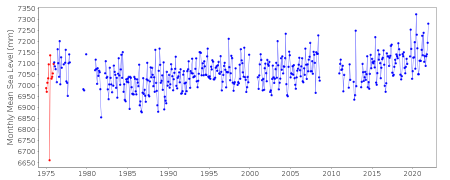
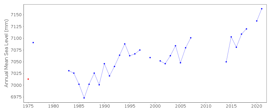
| Time span of data: | 1975 – 2025 |
| Completeness (%): | 83 |
| Date of last update: | 07 Jul 2026 |
| Green Arrow: | Current Station |
| Yellow Marker: | Neighbouring RLR Station |
| Red Marker: | Neighbouring Metric Station |
Please note: In many cases, the station position in our database is accurate to only one minute. Thus, the tide gauge may not appear to be on the coast.
Tide Gauge Data
Station Documentation
Link to RLR information.Documentation added 1994-05-23
JUNE 1975 and JANUARY-APRIL 1978 UNRELIABLEDocumentation added 1994-08-04
For a discussion of interannual variability of sea level along the coasts of Pakistan and India, see Clarke and Liu, Journal of Physical Oceanography, 24, 1224, 1994.Documentation added 2002-12-06
SMRC Newsletter Jul-Dec 2001 reports high E coast correlation with SOI and MSL.MSL is much higher during La Nina tropical cyclones than during El Nino.Documentation added 2003-01-27
Unreasonable values of JAN=2782, FEB=2761, MAR=2806 and APR=2869 deleted from 1978. See previous comments dated 23/05/94.Documentation added 2010-09-16
Primary benchmark is BM 52 PP 5.23m above chart datum. This station was previously flagged. However, as individual data points can now be flagged the period commented on above has been flagged and the station flag removed.Data Authority
Survey of IndiaGeodetic and Research Branch
17 E.C. Road
Dehra Dun
PIN 248 001

![]()
![]()
![]()
