Data
- Obtaining
- Supplying
- High-Frequency
- Bottom Pressure Records
- Other Long Records
- GLOSS/ODINAFRICA Calibration Data
Donate
Donate to PSMSL
Data Notes
- Individual Station Data and Plot Notes
- Referencing the Data Set
- PSMSL Help File
- 2010 Changes to the PSMSL Data Files
Extracted from Database
13 Jul 2026
Station Information
| Station ID: | 1392 |
| Latitude: | 48.333333 |
| Longitude: | -70.866667 |
| Coastline code: | 970 |
| Station code: | 95 |
| Country: | CANADA |
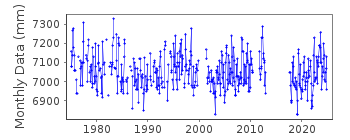
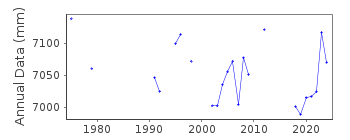
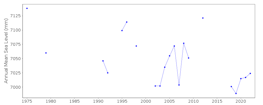
| Time span of data: | 1975 – 2024 |
| Completeness (%): | 72 |
| Date of last update: | 19 Jun 2025 |
| Green Arrow: | Current Station |
| Yellow Marker: | Neighbouring RLR Station |
| Red Marker: | Neighbouring Metric Station |
Please note: In many cases, the station position in our database is accurate to only one minute. Thus, the tide gauge may not appear to be on the coast.
Tide Gauge Data
Station Documentation
Link to RLR information.Documentation added 1994-03-23
data up to 1992 revised, March 1994Documentation added 2008-09-18
RLR calculated for this station 17.9.08Documentation added 2011-09-06
Primary benchmark remains 79L003 21.571m above TGZDocumentation added 2014-07-30
The tide gauge at Port Alfred is currently not operational. We have been informed that there are no plans at this time to have it back on the network.Documentation added 2015-07-27
This year, rather than just sending the latest year of data the complete dataset has been supplied. This has highlighted some differences in the data. From communications in the correspondence file for 2002 it appears that the Oceans and Fisheries meant to supply revised data for the stations supplied. This did not happen. The complete dataset includes these data revisions. Therefore, the whole dataset has now been re-entered.The tide gauge at Port Alfred has now been removed.
Documentation added 2019-06-18
Station Port Alfred was re-installed in mid July 2017 due to some external pressure and the fact that it is a reference port in the Canadian Tide Tables. The new station has been levelled to the previous benchmarks.Data Authority
Canadian Hydrographic Service615 Booth Street
Ottawa
Ontario K1A 0E6

![]()
![]()
![]()
