Data
- Obtaining
- Supplying
- High-Frequency
- Bottom Pressure Records
- Other Long Records
- GLOSS/ODINAFRICA Calibration Data
Donate
Donate to PSMSL
Data Notes
- Individual Station Data and Plot Notes
- Referencing the Data Set
- PSMSL Help File
- 2010 Changes to the PSMSL Data Files
Extracted from Database
13 Jul 2026
Station Information
| Station ID: | 1373 |
| Latitude: | -9.433333 |
| Longitude: | 159.95 |
| GLOSS ID: | 66 |
| Coastline code: | 734 |
| Station code: | 2 |
| Country: | SOLOMON ISLANDS |
| Time span of data: | 1974 – 1994 |
| Completeness (%): | 93 |
| Link to ellipsoid: | Available |
| Date of last update: | 07 Nov 1996 |
| Green Arrow: | Current Station |
| Yellow Marker: | Neighbouring RLR Station |
| Red Marker: | Neighbouring Metric Station |
Please note: In many cases, the station position in our database is accurate to only one minute. Thus, the tide gauge may not appear to be on the coast.
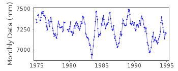
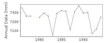
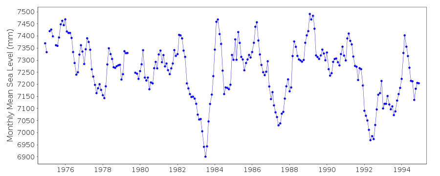
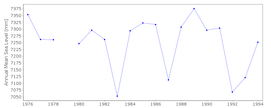
Tide Gauge Data
Additional Data Sources (guide to additional data sources)
Nearby GNSS Stations from SONEL: SOLONearby Real Time Stations from VLIZ: solo
Fast Delivery Data from UHSLC station 9: hourly and daily
Research Quality Data from UHSLC station 9: hourly and daily
Station Documentation
Link to RLR information.Documentation added 1991-06-11
Honiara II 734/002 RLR(1983) is 9.0m below BMUH-1Documentation added 1996-10-07
Instrument type:(1974-present) Leupold and Stevens Analog-to-Digital Recorder (ADR); (11/1984-present) Handar Encoder (ENC)Primary gauge: ADR:1974-90, ENC 1991-95Documentation added 1998-01-07
4 January 1995: Aquatrak acoustic gauge (SEAFRAME) installed by the National Tidal Facility (NTF). NTF has now taken over the running of the gauge.Documentation added 2000-04-11
All data has been received from the UHSLCData Authority
University of Hawaii Sea Level CenterDepartment of Oceanography Division of Natural Sciences
1000 Pope Road
Honolulu
Hawaii 96822

![]()
![]()
![]()
