Data
- Obtaining
- Supplying
- High-Frequency
- Bottom Pressure Records
- Other Long Records
- GLOSS/ODINAFRICA Calibration Data
Donate
Donate to PSMSL
Data Notes
- Individual Station Data and Plot Notes
- Referencing the Data Set
- PSMSL Help File
- 2010 Changes to the PSMSL Data Files
Extracted from Database
13 Jul 2026
Station Information
| Station ID: | 1356 |
| Latitude: | 22.533333 |
| Longitude: | 120.316667 |
| Coastline code: | 612 |
| Station code: | 12 |
| Country: | TAIWAN, PROVINCE OF CHINA |
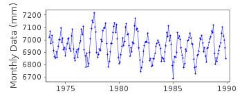
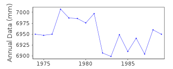
| Time span of RLR data: | 1973 – 1989 |
| RLR completeness (%): | 97 |
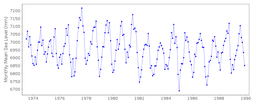
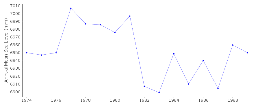
| Time span of metric data: | 1973 – 1996 |
| Metric completeness (%): | 98 |
| Date of last update: | 28 Apr 1998 |
| Green Arrow: | Current Station |
| Yellow Marker: | Neighbouring RLR Station |
| Red Marker: | Neighbouring Metric Station |
Please note: In many cases, the station position in our database is accurate to only one minute. Thus, the tide gauge may not appear to be on the coast.
Tide Gauge Data
Additional Data Sources (guide to additional data sources)
Nearby Real Time Stations from VLIZ: tkaoFast Delivery Data from UHSLC station 340: hourly and daily
Research Quality Data from UHSLC station 340: hourly and daily
Station Documentation
Link to RLR information.Documentation added 1991-06-11
Kaohsiung II 612/012 RLR(1988) is 8.6m below Standard MarkDocumentation added 1993-07-12
Kaohsiung II 612/012 RLR(1988) is 8.6m below Standard MarkDocumentation added 1996-02-26
data 1990-91 received from TOGA officeDocumentation added 2012-01-18
Using data from the latest UHSLC JASL cd the 'METRIC' data for Kaohsung hasbeen updated. Data for 1997-2010 has been added to the dataset. Although the
added data is to a different datum it was thought it would add to the dataset.
Data Authority
Central Weather Bureau64 Kung Yuan Road
Taipei
Taiwan 10039

![]()
![]()
![]()
