Data
- Obtaining
- Supplying
- High-Frequency
- Bottom Pressure Records
- Other Long Records
- GLOSS/ODINAFRICA Calibration Data
Donate
Donate to PSMSL
Data Notes
- Individual Station Data and Plot Notes
- Referencing the Data Set
- PSMSL Help File
- 2010 Changes to the PSMSL Data Files
Extracted from Database
13 Jul 2026
Station Information
| Station ID: | 135 |
| Latitude: | 39.933333 |
| Longitude: | -75.141667 |
| Coastline code: | 960 |
| Station code: | 87 |
| Country: | UNITED STATES |
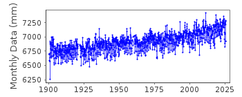
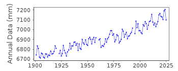
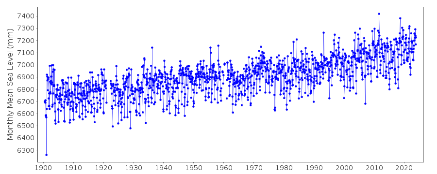
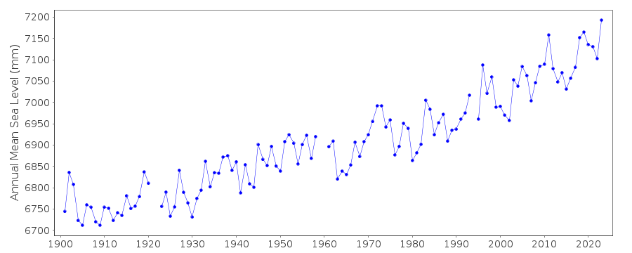
| Time span of data: | 1900 – 2025 |
| Completeness (%): | 97 |
| Date of last update: | 27 Jan 2026 |
| Green Arrow: | Current Station |
| Yellow Marker: | Neighbouring RLR Station |
| Red Marker: | Neighbouring Metric Station |
Please note: In many cases, the station position in our database is accurate to only one minute. Thus, the tide gauge may not appear to be on the coast.
Tide Gauge Data
Station Documentation
Link to RLR information.Documentation added 1991-06-11
Philadelphia 960/087 RLR(1971) is 9.8m below BM21Documentation added 2012-02-15
Data 1900-1989 for Philadelphia on the NOAA website is NOAA No. 845 5530 where primary benchmark is listed as 35 1931 3.802m above TGZ. This information is written on the original RLR diagram. From 1989 onwards delegated NOAA number is 845 5240 4.688m above TGZ. Benchmark 21 from the original RLR diagra no longer features on the NOAA website.Data Authority
N.O.A.A. / N.O.S.N/oes33, Ssmc4, Room 6531
1305 East-West Highway
Silver Spring,
MD 20910

![]()
![]()
![]()
