Data
- Obtaining
- Supplying
- High-Frequency
- Bottom Pressure Records
- Other Long Records
- GLOSS/ODINAFRICA Calibration Data
Donate
Donate to PSMSL
Data Notes
- Individual Station Data and Plot Notes
- Referencing the Data Set
- PSMSL Help File
- 2010 Changes to the PSMSL Data Files
Extracted from Database
20 Jul 2026
WARNING: QCFLAG EXISTS. PLEASE READ THE DOCUMENTATION.
Station Information
| Station ID: | 1346 |
| Latitude: | 39.273333 |
| Longitude: | 141.889167 |
| Coastline code: | 642 |
| Station code: | 17 |
| Country: | JAPAN |
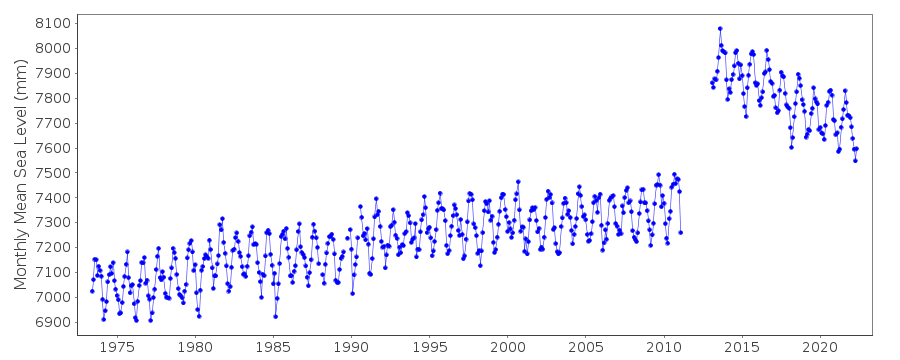
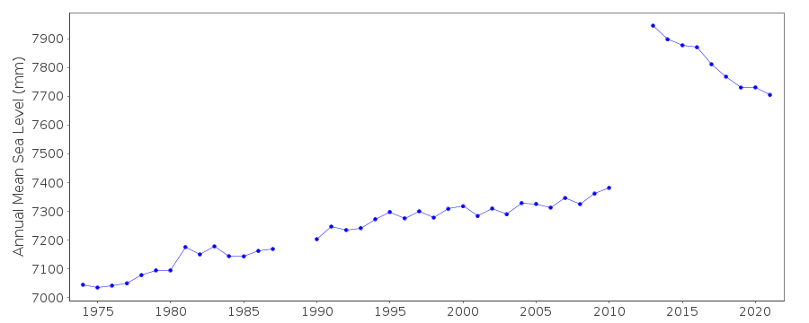
| Time span of data: | 1973 – 2022 |
| Completeness (%): | 93 |
| Date of last update: | 03 Feb 2023 |
| Green Arrow: | Current Station |
| Yellow Marker: | Neighbouring RLR Station |
| Red Marker: | Neighbouring Metric Station |
Please note: In many cases, the station position in our database is accurate to only one minute. Thus, the tide gauge may not appear to be on the coast.
Tide Gauge Data
Station Documentation
Link to RLR information.Documentation added 1991-06-11
Kamaisi II 642/017 RLR(1975) is 8.6m below BM KamaisiDocumentation added 2012-02-22
A massive earthquake magnitude 9.0 occurred at 14.46 JST (05.46 UTC) on Friday 11th March 2011 with the epicentre situated approx. 70km east of the Oshika Peninsula of Tohoku. It was the largest earthquake ever to strike Japan and triggered a tsunami with waves of up to 40.5m travelling inland up to 10km.Documentation added 2022-04-05
Following review of data affected by the Tōhoku earthquake of 2011, all data has been flagged as good as GSI have recommenced levelling at the site. The station flag has been set to indicate the record needs to be treated with care, but the data appears to accurately reflect the earthquake's ongoing effect on local relative sea level.Data Authority
Japan Oceanographic Data CentreHydrographic Department, Maritime Safety Agency
MLIT Aomi Building
2-5-18, Aomi, Koto-ku
Tokyo 135-0064

![]()
![]()
![]()
