Data
- Obtaining
- Supplying
- High-Frequency
- Bottom Pressure Records
- Other Long Records
- GLOSS/ODINAFRICA Calibration Data
Donate
Donate to PSMSL
Data Notes
- Individual Station Data and Plot Notes
- Referencing the Data Set
- PSMSL Help File
- 2010 Changes to the PSMSL Data Files
Extracted from Database
13 Jul 2026
Station Information
| Station ID: | 1284 |
| Latitude: | 47.85 |
| Longitude: | -69.566667 |
| Coastline code: | 970 |
| Station code: | 64 |
| Country: | CANADA |
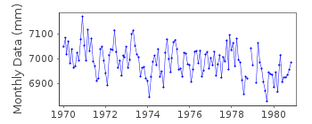
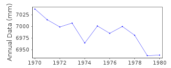
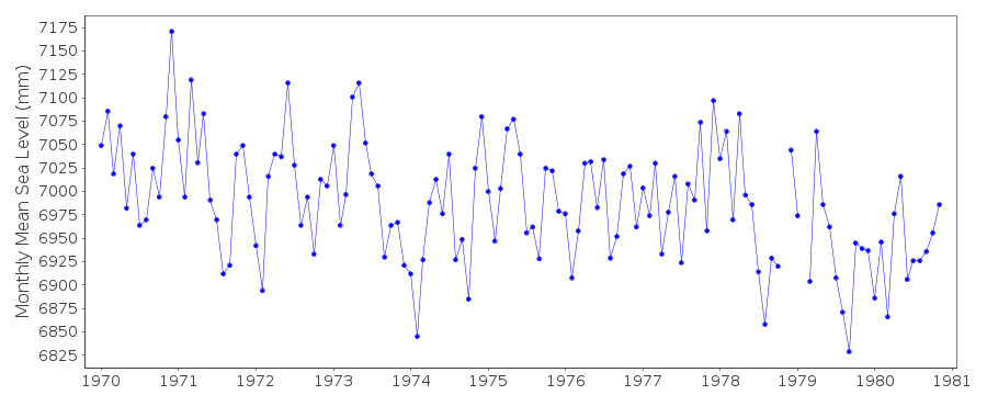
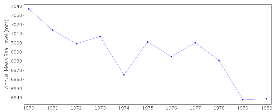
| Time span of data: | 1970 – 1980 |
| Completeness (%): | 98 |
| Date of last update: | 07 Jun 1989 |
| Green Arrow: | Current Station |
| Yellow Marker: | Neighbouring RLR Station |
| Red Marker: | Neighbouring Metric Station |
Please note: In many cases, the station position in our database is accurate to only one minute. Thus, the tide gauge may not appear to be on the coast.
Tide Gauge Data
Station Documentation
Link to RLR information.Documentation added 1991-06-11
Riviere du Loup 970/064 RLR(1972) is 12.1m below BM BR-ADMDocumentation added 1993-07-12
Riviere du Loup 970/064 RLR(1972) is 12.1m below BM BR-ADMDocumentation added 1993-11-02
Since 1980 monthly means received from Canadian authority are in cm.Documentation added 2010-08-19
TGBM BM BR-ADM was the primary benchmark 1968-1978. Benchmark BM 4-1963 was theprimary 1979 onwards. RLR does not change as the datum remains the same. RLR
factor is 6.976.
Data Authority
Canadian Hydrographic Service615 Booth Street
Ottawa
Ontario K1A 0E6

![]()
![]()
![]()
