Data
- Obtaining
- Supplying
- High-Frequency
- Bottom Pressure Records
- Other Long Records
- GLOSS/ODINAFRICA Calibration Data
Donate
Donate to PSMSL
Data Notes
- Individual Station Data and Plot Notes
- Referencing the Data Set
- PSMSL Help File
- 2010 Changes to the PSMSL Data Files
Extracted from Database
13 Jul 2026
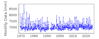
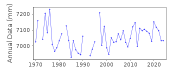
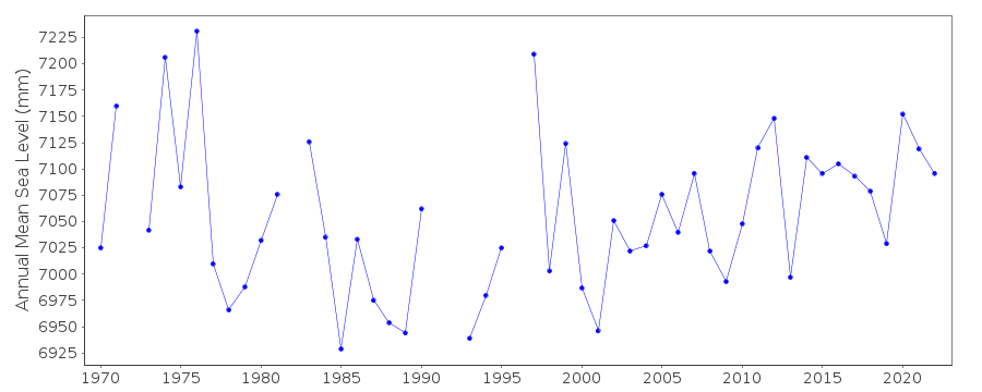
Station Information
| Station ID: | 1245 |
| Latitude: | 49.2 |
| Longitude: | -122.916667 |
| Coastline code: | 822 |
| Station code: | 75 |
| Country: | CANADA |
| Time span of data: | 1969 – 2024 |
| Completeness (%): | 95 |
| Date of last update: | 19 Jun 2025 |
| Green Arrow: | Current Station |
| Yellow Marker: | Neighbouring RLR Station |
| Red Marker: | Neighbouring Metric Station |
Please note: In many cases, the station position in our database is accurate to only one minute. Thus, the tide gauge may not appear to be on the coast.
Tide Gauge Data
Station Documentation
Link to RLR information.Documentation added 1994-03-23
data up to 1991 revised, March 1994Documentation added 1994-07-12
Large amplitude of seasonal cycle indicates a gauge near a river.Documentation added 1994-07-15
New Westminster 822/075 RLR(1986) is 10.5m below BM 13-JDocumentation added 2013-05-07
Previously this station was flagged presumably because of its proximity to a river. The sea level profile however looks good. The station flag has been removed.Documentation added 2015-07-27
This year, rather than just sending the latest year of data, the complete dataset has been supplied. This has highlighted some differences in the data. From communications in the correspondence file for 2002 it appears that the Oceans and Fisheries meant to supply revised data for the stations supplied. This did not happen. The complete dataset includes these data revisions. Therefore, the whole dataset has now been re-entered.Data Authority
Canadian Hydrographic Service615 Booth Street
Ottawa
Ontario K1A 0E6

![]()
![]()
![]()
