Data
- Obtaining
- Supplying
- High-Frequency
- Bottom Pressure Records
- Other Long Records
- GLOSS/ODINAFRICA Calibration Data
Donate
Donate to PSMSL
Data Notes
- Individual Station Data and Plot Notes
- Referencing the Data Set
- PSMSL Help File
- 2010 Changes to the PSMSL Data Files
Extracted from Database
13 Jul 2026
Station Information
| Station ID: | 1239 |
| Latitude: | 38.834544 |
| Longitude: | 20.712108 |
| Coastline code: | 290 |
| Station code: | 4 |
| Country: | GREECE |
| Time span of data: | 1969 – 2025 |
| Completeness (%): | 86 |
| Date of last update: | 13 Mar 2026 |
| Green Arrow: | Current Station |
| Yellow Marker: | Neighbouring RLR Station |
| Red Marker: | Neighbouring Metric Station |
Please note: In many cases, the station position in our database is accurate to only one minute. Thus, the tide gauge may not appear to be on the coast.
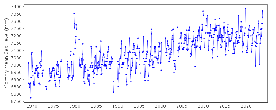
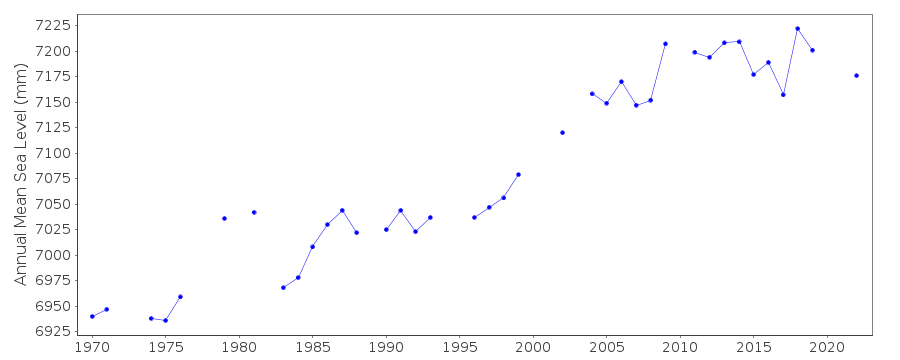
Tide Gauge Data
Station Documentation
Link to RLR information.Documentation - date unknown
1969-76 1978-79 Data from readings of tide poleDocumentation added 1991-06-11
Levkas 290/004 RLR(1981) is 8.1m below BM RBDocumentation added 1997-03-11
The contributing authority advises that anomalous values are the result of met. influencesDocumentation added 2007-03-19
Following instructions from HNHS, see letter of 22.02.07 the RLR value for this station has been revised to 6.500Documentation added 2009-01-28
Treat data 1979-1982 as suspect.Documentation added 2010-03-04
There has been some confusion with the Greek stations as they change from recording the sea level height downwards to the more conventional upwards measurement. For this reason RLR was revoked at Lefkas. However with the addition of 2009 data the dataset looks OK. RLR has been re-instated.Documentation added 2011-03-03
When Levkas was buddy checked with Prevesa the early data for Levkas 1969-1979 appears low.Documentation added 2013-10-07
Using values supplied by the Hellenic Navy the RLR diagram for Levkas has been re-drawn.Data Authority
Hellenic Navy Hydrographic ServiceGeographic Policy and International Relations Office
TGN 1040
Athens

![]()
![]()
![]()
