Data
- Obtaining
- Supplying
- High-Frequency
- Bottom Pressure Records
- Other Long Records
- GLOSS/ODINAFRICA Calibration Data
Donate
Donate to PSMSL
Data Notes
- Individual Station Data and Plot Notes
- Referencing the Data Set
- PSMSL Help File
- 2010 Changes to the PSMSL Data Files
Extracted from Database
13 Jul 2026
Station Information
| Station ID: | 1232 |
| Latitude: | 35.487453 |
| Longitude: | 24.082481 |
| Coastline code: | 290 |
| Station code: | 97 |
| Country: | GREECE |
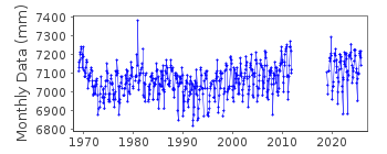
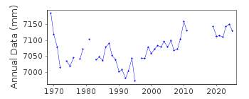
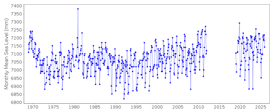
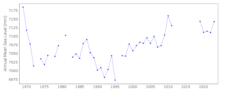
| Time span of data: | 1969 – 2025 |
| Completeness (%): | 84 |
| Date of last update: | 13 Mar 2026 |
| Green Arrow: | Current Station |
| Yellow Marker: | Neighbouring RLR Station |
| Red Marker: | Neighbouring Metric Station |
Please note: In many cases, the station position in our database is accurate to only one minute. Thus, the tide gauge may not appear to be on the coast.
Tide Gauge Data
Station Documentation
Link to RLR information.Documentation - date unknown
1969-73 Data from readings of tide poleDocumentation added 1991-06-11
Soudhas 290/097 RLR(1976) is 10.2m below BM R145Documentation added 1997-03-11
The contributing authority advises that anomalous values are the result of met. influencesDocumentation added 2008-04-09
During local works the benchmark R145 was destroyed. The current benchmark values are R144 16.107m R12 2.618m R11 2.512, R25 2.446m R10 2.183 PSMSL is currently in correspondence with HNHSto establish the relationship of these revised benchmarks with R145. Until this is resolved the station has been revised to a Metric station.
Documentation added 2011-03-03
The Hellenic Navy do not have any values for the relationship between the previous benchmark R145 and the new benchmarks. Data for 2002 to be left 'Metric' for now and station has been flagged. As there is unlikely to be further information on the relationship between benchmark R145 and the currently used benchmarks the data series has been split. Data for 2002 onwards is now SOUDAS II id. 2067.Documentation added 2013-08-12
Using new datum information from the Hellenic Navy the dataset for Soudhas has been re-combined. No further data will be added to Soudhas II id. 2067.Data Authority
Hellenic Navy Hydrographic ServiceGeographic Policy and International Relations Office
TGN 1040
Athens

![]()
![]()
![]()
