Data
- Obtaining
- Supplying
- High-Frequency
- Bottom Pressure Records
- Other Long Records
- GLOSS/ODINAFRICA Calibration Data
Donate
Donate to PSMSL
Data Notes
- Individual Station Data and Plot Notes
- Referencing the Data Set
- PSMSL Help File
- 2010 Changes to the PSMSL Data Files
Extracted from Database
13 Jul 2026
Station Information
| Station ID: | 1224 |
| Latitude: | 51.85 |
| Longitude: | 1.266667 |
| Coastline code: | 170 |
| Station code: | 74 |
| Country: | UNITED KINGDOM |
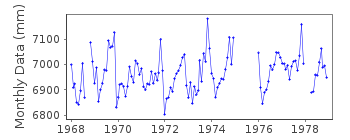
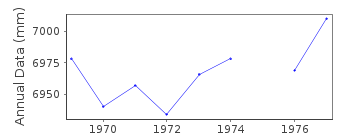
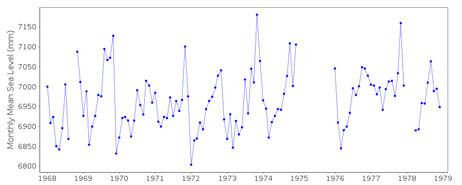
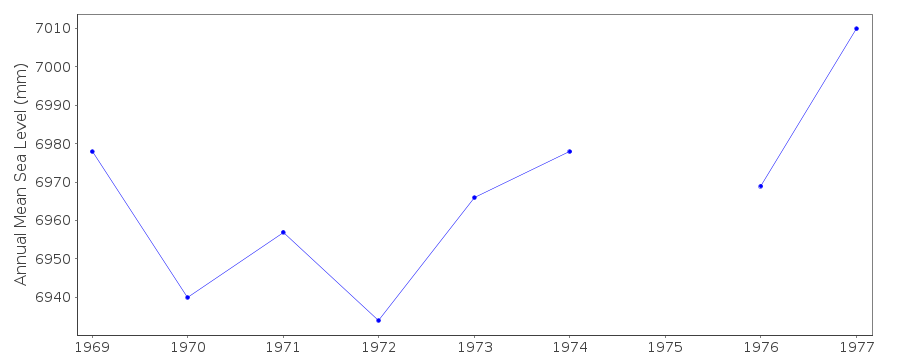
| Time span of data: | 1968 – 1978 |
| Completeness (%): | 87 |
| Date of last update: | 20 Feb 1991 |
| Green Arrow: | Current Station |
| Yellow Marker: | Neighbouring RLR Station |
| Red Marker: | Neighbouring Metric Station |
Please note: In many cases, the station position in our database is accurate to only one minute. Thus, the tide gauge may not appear to be on the coast.
Tide Gauge Data
Station Documentation
Link to RLR information.Documentation added 1991-06-11
Walton on the Naze 170/074 RLR(1977) is 10.5m below BM TM 2601 2119Documentation added 1993-07-12
Walton on the Naze 170/074 RLR(1977) is 10.5m below BM TM 2601 2119Documentation added 1994-07-20
Gauge was a Lea stilling well type.Documentation added 1994-09-20
1975 - well damaged, no dataWalton on the Naze is an historic station last data 1978
Documentation added 2001-01-02
Recent work on vertical land movements in the UK can be found fromthe University of Nottingham web site:
http://ukcogr.iessg.nottingham.ac.uk/~eosi/
Data Authority
British Oceanographic Data CentreNational Oceanography Centre
Joseph Proudman Building, 6 Brownlow Street
Liverpool
L3 5DA

![]()
![]()
![]()
